![](/images/other/stat-length.png)
![Trail Walking Notre-Dame-de-Londres - le ravin des arcs arsel - Photo](https://media.geolcdn.com/t/1900/400/ext.pjpeg?maxdim=2&url=https%3A%2F%2Fmedia.geolcdn.com%2Ff%2Fc2ba09d0-1f82-4755-8486-47927c1e5e15.jpg)
le ravin des arcs arsel
labarone
User
![Length](/images/other/stat-length.png)
Length
17.4 km
![Max alt](https://static1.geolcdn.com/siteimages/upload/files/1508320355ic_sort_altitude_max_24dp.png)
Max alt
329 m
![Uphill gradient](https://static1.geolcdn.com/siteimages/upload/files/1508320355ic_sort_den_pos_24dp.png)
Uphill gradient
601 m
![Km-Effort](/images/other/stat-length.png)
Km-Effort
25 km
![Min alt](https://static1.geolcdn.com/siteimages/upload/files/1508320355ic_sort_altitude_min_24dp.png)
Min alt
109 m
![Downhill gradient](https://static1.geolcdn.com/siteimages/upload/files/1508320355ic_sort_den_neg_24dp.png)
Downhill gradient
599 m
![Boucle](https://static1.geolcdn.com/siteimages/upload/files/16400158638029165_repeat_loop_refresh_sync_direction_icon.png)
Boucle
Yes
Creation date :
2020-10-06 06:13:41.063
Updated on :
2020-10-06 13:49:47.981
![Walking](https://static1.geolcdn.com/sitytour/trail-icons/101.png)
7h00
Difficulty : Difficult
![Scan this QR Code to open this trail in the SityTrail application](https://capi.geolives.com/qq0zvz2zws4bq2lad0pu/sitytour/trails/2569976/qr.png?size=200)
FREE GPS app for hiking
About
Trail Walking of 17.4 km to be discovered at Occitania, Hérault, Notre-Dame-de-Londres. This trail is proposed by labarone.
Description
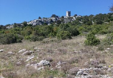
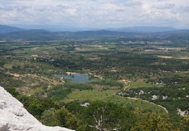
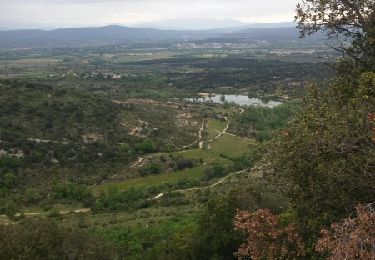
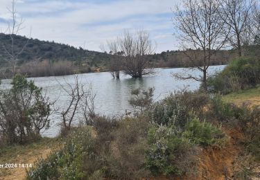
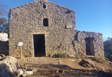
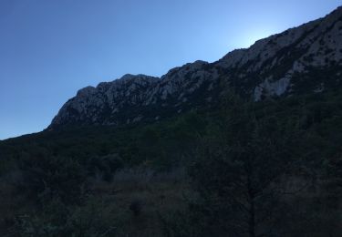
tres belle rando voir photos
attention premiere partie difficile en descente. Ensuite dans le ravin tres attention autour des marmittes ...personne sensible au vertige s abstenir. rando a faire car splendide !
Positioning
Country:
France
Region :
Occitania
Department/Province :
Hérault
Municipality :
Notre-Dame-de-Londres
Location:
Unknown
Start:(Dec)
Start:(UTM)
559667 ; 4851276 (31T) N.
Comments
Trails nearby
![Trail Walking Cazevieille - le tour du pic st loup - Photo](https://media.geolcdn.com/t/375/260/ext.jpg?maxdim=2&url=https%3A%2F%2Fservices.sitytrail.com%2FGeolivesWS%2FDownloadMedia.ashx%3FTrailID%3D564155%26Media%3Dfix__20160505154449.jpg)
![Walking Walking](https://static1.geolcdn.com/sitytour/trail-icons/101.png)
le tour du pic st loup
Walking
Medium
(1)
Cazevieille,
Occitania,
Hérault,
France
![](/images/other/stat-length.png)
11.4 km | 19.8 km-effort
4h 34min
![](https://static1.geolcdn.com/siteimages/upload/files/16400158638029165_repeat_loop_refresh_sync_direction_icon.png)
Yes
![Trail Walking Cazevieille - cazevieille-pic st loup-lac fe la jasse - Photo](https://media.geolcdn.com/t/375/260/ext.jpg?maxdim=2&url=https%3A%2F%2Fservices.sitytrail.com%2FGeolivesWS%2FDownloadMedia.ashx%3FTrailID%3D579300%26Media%3Dfix__20160604134108.jpg)
![Walking Walking](https://static1.geolcdn.com/sitytour/trail-icons/101.png)
cazevieille-pic st loup-lac fe la jasse
Walking
Difficult
(2)
Cazevieille,
Occitania,
Hérault,
France
![](/images/other/stat-length.png)
14.7 km | 23 km-effort
5h 21min
![](https://static1.geolcdn.com/siteimages/upload/files/16400158638029165_repeat_loop_refresh_sync_direction_icon.png)
Yes
![Trail Nordic walking Cazevieille - cazevieille + lac de la jasse - Photo](https://media.geolcdn.com/t/375/260/ext.jpg?maxdim=2&url=https%3A%2F%2Fservices.sitytrail.com%2FGeolivesWS%2FDownloadMedia.ashx%3FTrailID%3D565622%26Media%3Dfix__20160508095919.jpg)
![Nordic walking Nordic walking](https://static1.geolcdn.com/sitytour/trail-icons/102.png)
cazevieille + lac de la jasse
Nordic walking
Medium
(1)
Cazevieille,
Occitania,
Hérault,
France
![](/images/other/stat-length.png)
9.5 km | 13.6 km-effort
2h 32min
![](https://static1.geolcdn.com/siteimages/upload/files/16400158638029165_repeat_loop_refresh_sync_direction_icon.png)
Yes
![Trail Walking Notre-Dame-de-Londres - Ravin des Arc 01 - Photo](https://media.geolcdn.com/t/375/260/ext.jpg?maxdim=2&url=https%3A%2F%2Fstatic1.geolcdn.com%2Fsiteimages%2Fupload%2Ffiles%2F1553511878bg_sport_marche.png)
![Walking Walking](https://static1.geolcdn.com/sitytour/trail-icons/101.png)
Ravin des Arc 01
Walking
Medium
(3)
Notre-Dame-de-Londres,
Occitania,
Hérault,
France
![](/images/other/stat-length.png)
5.9 km | 8.6 km-effort
1h 53min
![](https://static1.geolcdn.com/siteimages/upload/files/16400158638029165_repeat_loop_refresh_sync_direction_icon.png)
Yes
![Trail Walking Mas-de-Londres - La Jasse Cazevieille par l’ubac - Photo](https://media.geolcdn.com/t/375/260/ext.jpg?maxdim=2&url=https%3A%2F%2Fmedia.geolcdn.com%2Ff%2F9a13e1f3-2499-4387-bf75-45d970603d81.jpg)
![Walking Walking](https://static1.geolcdn.com/sitytour/trail-icons/101.png)
La Jasse Cazevieille par l’ubac
Walking
Medium
Mas-de-Londres,
Occitania,
Hérault,
France
![](/images/other/stat-length.png)
12.6 km | 16 km-effort
3h 43min
![](https://static1.geolcdn.com/siteimages/upload/files/16400158638029165_repeat_loop_refresh_sync_direction_icon.png)
Yes
![Trail Walking Notre-Dame-de-Londres - ND-de-Londres_Chutes_Lamalou - Photo](https://media.geolcdn.com/t/375/260/ext.jpg?maxdim=2&url=https%3A%2F%2Fmedia.geolcdn.com%2Ff%2Fcc86ec54-6797-4ec2-b4ff-89965130e43a.jpg)
![Walking Walking](https://static1.geolcdn.com/sitytour/trail-icons/101.png)
ND-de-Londres_Chutes_Lamalou
Walking
Medium
Notre-Dame-de-Londres,
Occitania,
Hérault,
France
![](/images/other/stat-length.png)
11.5 km | 14.2 km-effort
3h 30min
![](https://static1.geolcdn.com/siteimages/upload/files/16400158638029165_repeat_loop_refresh_sync_direction_icon.png)
Yes
![Trail Walking Saint-Martin-de-Londres - Saint-Martin-de-Londres-la-jasse - Photo](https://media.geolcdn.com/t/375/260/ext.jpg?maxdim=2&url=https%3A%2F%2Fmedia.geolcdn.com%2Ff%2F42714f9a-1fe4-412e-91c6-2e130dc1d617.jpg)
![Walking Walking](https://static1.geolcdn.com/sitytour/trail-icons/101.png)
Saint-Martin-de-Londres-la-jasse
Walking
Medium
Saint-Martin-de-Londres,
Occitania,
Hérault,
France
![](/images/other/stat-length.png)
14.4 km | 17.1 km-effort
4h 16min
![](https://static1.geolcdn.com/siteimages/upload/files/16400158638029165_repeat_loop_refresh_sync_direction_icon.png)
Yes
![Trail Walking Cazevieille - Pic St Loup + Crête 16.12.23 - Photo](https://media.geolcdn.com/t/375/260/ext.jpg?maxdim=2&url=https%3A%2F%2Fmedia.geolcdn.com%2Ff%2Fbfdaf89a-9773-4f5d-a083-c292c0cb02a4.jpg)
![Walking Walking](https://static1.geolcdn.com/sitytour/trail-icons/101.png)
Pic St Loup + Crête 16.12.23
Walking
Difficult
Cazevieille,
Occitania,
Hérault,
France
![](/images/other/stat-length.png)
6.7 km | 11.6 km-effort
4h 15min
![](https://static1.geolcdn.com/siteimages/upload/files/16400158638029165_repeat_loop_refresh_sync_direction_icon.png)
Yes
![Trail Walking Mas-de-Londres - tour du Pic St Loup - Photo](https://media.geolcdn.com/t/375/260/ext.jpg?maxdim=2&url=https%3A%2F%2Fmedia.geolcdn.com%2Ff%2F454f4453-86c9-48a0-8b22-c42a379f5d4f.jpg)
![Walking Walking](https://static1.geolcdn.com/sitytour/trail-icons/101.png)
tour du Pic St Loup
Walking
Medium
Mas-de-Londres,
Occitania,
Hérault,
France
![](/images/other/stat-length.png)
14.8 km | 23 km-effort
4h 30min
![](https://static1.geolcdn.com/siteimages/upload/files/16400158638029165_repeat_loop_refresh_sync_direction_icon.png)
Yes