


WETTOLSHEIM

jcschubnel
User
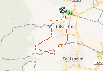

Length
5.6 km

Max alt
340 m

Uphill gradient
137 m
Km-Effort
7.4 km

Min alt
204 m

Downhill gradient
136 m
Boucle
Yes
Creation date :
2020-10-06 12:22:36.39
Updated on :
2020-10-06 16:24:48.85
1h36
Difficulty : Very easy

FREE GPS app for hiking
 SityTrail
IGN / Geographical institutes
SityTrail Plus
The world is yours!
About
Trail Walking of 5.6 km to be discovered at Grand Est, Haut-Rhin, Wettolsheim. This trail is proposed by jcschubnel.
Positioning
Country:
France
Region :
Grand Est
Department/Province :
Haut-Rhin
Municipality :
Wettolsheim
Location:
Unknown
Start:(Dec)
Start:(UTM)
373581 ; 5324467 (32U) N.
Comments