


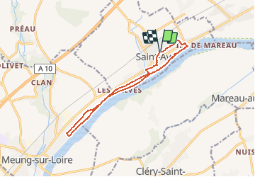


13.1 km | 14.4 km-effort


Si tu veux marcher vite, marche seul; si tu veux marcher loin, marche avec les autres.


FREE GPS app for hiking
 SityTrail
IGN / Geographical institutes
SityTrail World
The world is yours!
Trail Walking of 12 km to be discovered at Centre-Loire Valley, Loiret, Saint-Ay. This trail is proposed by CLÉRY Rando.

Mountain bike
Walking

Walking

Walking

Mountain bike
Walking
Cycle

Road bike

Walking