Trail Walking Mézières-lez-Cléry - Mézières 6 juin 2021 - Photo
© OpenStreetMap contributors
Length
Length
9.9 km
Max alt
Max alt
117 m
Uphill gradient
Uphill gradient
74 m
Km-Effort
Km-Effort  
10.9 km
Min alt
Min alt
94 m
Downhill gradient
Downhill gradient
75 m
Boucle
Boucle
Yes
Creation date :
2021-06-06 06:55:31.333
Updated on :
2021-06-06 10:04:03.224

(0 Reviews)

Walking
Walking
3h07
Difficulty : Medium

Scan this QR Code to open this trail in the SityTrail application

FREE GPS app for hiking

Logo SityTrail SityTrail

IGN / Geographical institutes

Download SityTrail from the App Store Download SityTrail from Google Play

Logo SityTrail SityTrail World

The world is yours!

Download SityTrail from the App Store Download SityTrail from Google Play Download SityTrail on Huawei AppGallery

About

Trail Walking of 9.9 km to be discovered at Centre-Loire Valley, Loiret, Mézières-lez-Cléry. This trail is proposed by danieltaillandier.

Elevation profile

Photos

Positioning

Country:
France
Region :
Centre-Loire Valley
Department/Province :
Loiret
Municipality :
Mézières-lez-Cléry
Location:
Unknown
Start:(UTM)
410286 ; 5296805 (31T) N.

Trails nearby

Trail Walking Saint-Ay - ST AY bords de Loire 2 - Photo
Walking

Walking

Difficult
(1)
Saint-Ay, Centre-Loire Valley, Loiret, France
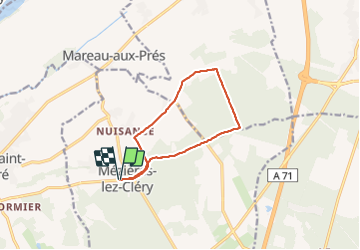
12 km | 13.4 km-effort
2h 57min
Yes
Trail Mountain bike Mézières-lez-Cléry - Les élus Mézière - Photo
Mountain bike
tracegps

Mountain bike

Medium
Mézières-lez-Cléry, Centre-Loire Valley, Loiret, France
13.1 km | 14.4 km-effort
1h 19min
Yes
Trail Walking Mézières-lez-Cléry - Les élus Mézière - Photo
Walking
tracegps

Walking

Easy
Mézières-lez-Cléry, Centre-Loire Valley, Loiret, France
13.1 km | 14.4 km-effort
3h 30min
Yes
Trail Walking Mézières-lez-Cléry - mezieres fevrier 2023 - Photo
Walking
bernard.music

Walking

Medium
Mézières-lez-Cléry, Centre-Loire Valley, Loiret, France
10.6 km | 11.8 km-effort
2h 28min
Yes
Trail Walking Olivet - Olivet - Tour des moulins - Photo
Walking
s0c7

Walking

Easy
Olivet, Centre-Loire Valley, Loiret, France
19.3 km | 21 km-effort
4h 34min
No
Trail Cycle Cléry-Saint-André - Cléry Saint André - Photo
Cycle
tracegps

Cycle

Easy
Cléry-Saint-André, Centre-Loire Valley, Loiret, France
19.2 km | 20 km-effort
1h 45min
Yes
Trail Walking Cléry-Saint-André - cler y3 - Photo
Walking
Rembliere

Walking

Easy
Cléry-Saint-André, Centre-Loire Valley, Loiret, France
4.3 km | 4.7 km-effort
1h 3min
Yes
Trail Walking Cléry-Saint-André - Clery 2 - Photo
Walking
Rembliere

Walking

Easy
Cléry-Saint-André, Centre-Loire Valley, Loiret, France
4.3 km | 4.5 km-effort
1h 1min
Yes
Trail Walking Cléry-Saint-André - Clery 1 - Photo
Walking
Rembliere

Walking

Easy
Cléry-Saint-André, Centre-Loire Valley, Loiret, France
4 km | 4.3 km-effort
58min
Yes


Close
My subscriptions