


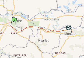
Voie verteMugron, Montaut 8.7

hartmannpat
User

Length
8.7 km

Max alt
119 m

Uphill gradient
141 m
Km-Effort
10.5 km

Min alt
44 m

Downhill gradient
117 m
Boucle
No
Creation date :
2020-01-16 17:26:22.395
Updated on :
2020-10-12 15:57:55.671
2h00
Difficulty : Easy

FREE GPS app for hiking
 SityTrail
IGN / Geographical institutes
SityTrail Plus
The world is yours!
About
Trail Walking of 8.7 km to be discovered at New Aquitaine, Landes, Mugron. This trail is proposed by hartmannpat.

Positioning
Country:
France
Region :
New Aquitaine
Department/Province :
Landes
Municipality :
Mugron
Location:
Unknown
Start:(Dec)
Start:(UTM)
681500 ; 4846485 (30T) N.
Comments