


MISTER VERS LE SATTEL

jcschubnel
User
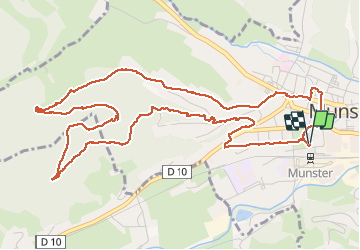

Length
6.8 km

Max alt
573 m

Uphill gradient
210 m
Km-Effort
9.6 km

Min alt
383 m

Downhill gradient
210 m
Boucle
Yes
Creation date :
2020-10-13 12:30:21.576
Updated on :
2020-10-13 15:54:52.476
2h17
Difficulty : Easy

FREE GPS app for hiking
 SityTrail
IGN / Geographical institutes
SityTrail Plus
The world is yours!
About
Trail Walking of 6.8 km to be discovered at Grand Est, Haut-Rhin, Munster. This trail is proposed by jcschubnel.
Positioning
Country:
France
Region :
Grand Est
Department/Province :
Haut-Rhin
Municipality :
Munster
Location:
Unknown
Start:(Dec)
Start:(UTM)
360916 ; 5322326 (32U) N.
Comments