


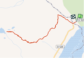
rieu claret lac de l'ane

lecmic
User

Length
6.3 km

Max alt
2432 m

Uphill gradient
687 m
Km-Effort
15.4 km

Min alt
1757 m

Downhill gradient
688 m
Boucle
Yes
Creation date :
2020-07-27 07:03:38.019
Updated on :
2020-10-16 08:15:52.317
4h35
Difficulty : Medium

FREE GPS app for hiking
 SityTrail
IGN / Geographical institutes
SityTrail Plus
The world is yours!
About
Trail Walking of 6.3 km to be discovered at Auvergne-Rhône-Alpes, Savoy, Saint-Colomban-des-Villards. This trail is proposed by lecmic.
Description
très belle rando
Positioning
Country:
France
Region :
Auvergne-Rhône-Alpes
Department/Province :
Savoy
Municipality :
Saint-Colomban-des-Villards
Location:
Unknown
Start:(Dec)
Start:(UTM)
275477 ; 5011900 (32T) N.
Comments