


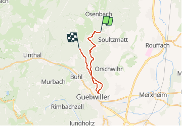
2020 10 17 Bannstein Soultzmatt

staubalex
User

Length
15.4 km

Max alt
590 m

Uphill gradient
451 m
Km-Effort
21 km

Min alt
308 m

Downhill gradient
255 m
Boucle
No
Creation date :
2020-10-17 11:14:11.766
Updated on :
2020-10-17 11:16:01.515
1h22
Difficulty : Easy
2h00
Difficulty : Medium

FREE GPS app for hiking
 SityTrail
IGN / Geographical institutes
SityTrail Plus
The world is yours!
About
Trail Mountain bike of 15.4 km to be discovered at Grand Est, Haut-Rhin, Soultzmatt. This trail is proposed by staubalex.
Positioning
Country:
France
Region :
Grand Est
Department/Province :
Haut-Rhin
Municipality :
Soultzmatt
Location:
Unknown
Start:(Dec)
Start:(UTM)
367309 ; 5314329 (32T) N.
Comments