Trail Walking Saint-Aulais-la-Chapelle - SAINT AULAIS pour AJM - Photo
 dorcier
dorcier

User

© OpenStreetMap contributors
Length
Length
11.1 km
Max alt
Max alt
130 m
Uphill gradient
Uphill gradient
140 m
Km-Effort
Km-Effort  
12.9 km
Min alt
Min alt
68 m
Downhill gradient
Downhill gradient
138 m
Boucle
Boucle
Yes
Creation date :
2020-10-19 14:57:29.733
Updated on :
2020-12-04 11:37:35.142

(0 Reviews)

Walking
Walking
2h49
Difficulty : Difficult

Scan this QR Code to open this trail in the SityTrail application

FREE GPS app for hiking

Logo SityTrail SityTrail

IGN / Geographical institutes

Download SityTrail from the App Store Download SityTrail from Google Play

Logo SityTrail SityTrail World

The world is yours!

Download SityTrail from the App Store Download SityTrail from Google Play Download SityTrail on Huawei AppGallery

About

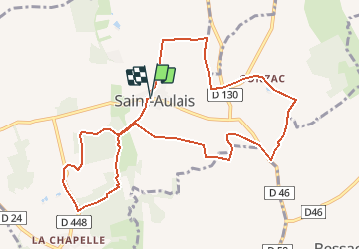
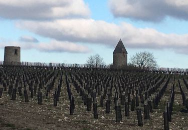
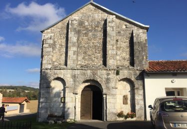
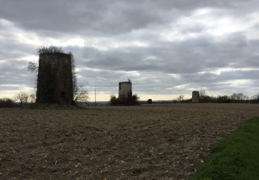
Trail Walking of 11.1 km to be discovered at New Aquitaine, Charente, Saint-Aulais-la-Chapelle. This trail is proposed by dorcier.

Description

circuit des 3 clochers
Départ parking de la mairie de Sint-Aulais.

Elevation profile

Photos

Points of interest

Point of interest Saint-Aulais-la-Chapelle - Pont romain - Photo
dorcier
SAINT-AULAIS-LA-CHAPELLE 
Point of interest Saint-Aulais-la-Chapelle - Eglise de Conzac XII eme siècle - Photo
dorcier
SAINT-AULAIS-LA-CHAPELLE 

Positioning

Country:
France
Region :
New Aquitaine
Department/Province :
Charente
Municipality :
Saint-Aulais-la-Chapelle
Location:
Unknown
Start:(UTM)
730624 ; 5036971 (30T) N.

Trails nearby

Trail Walking Bessac - Bessac (modifié) - Photo
Walking
dorcier

Walking

Difficult
Bessac, New Aquitaine, Charente, France
8.5 km | 10.4 km-effort
2h 54min
Yes
Trail Walking Coteaux-du-Blanzacais - cressac - Photo
Walking
dorcier

Walking

Easy
Coteaux-du-Blanzacais, New Aquitaine, Charente, France
7.4 km | 9.4 km-effort
2h 6min
Yes
Trail Walking Val-des-Vignes - Pereuil - Photo
Walking
dorcier

Walking

Easy
Val-des-Vignes, New Aquitaine, Charente, France
9.9 km | 12 km-effort
2h 37min
Yes
Trail Walking Bessac - tour haut de brie  - Photo
Walking
Pascal Dubois

Walking

Medium
Bessac, New Aquitaine, Charente, France
8.7 km | 10.7 km-effort
2h 7min
Yes
Trail On foot Deviat - Deviat Etang Jeannot - Photo
On foot
dorcier

On foot

Very easy
Deviat, New Aquitaine, Charente, France
5.7 km | 6.9 km-effort
Unknown
Yes
Trail On foot Deviat - Deviat Etang Jeannot - Photo
On foot
dorcier

On foot

Very easy
Deviat, New Aquitaine, Charente, France
5.6 km | 6.9 km-effort
1h 30min
Yes
Trail Walking Val-des-Vignes - chemin des moulins-Pereuil - 31-08-2014 - Photo
Walking
jmrobin

Walking

Medium
Val-des-Vignes, New Aquitaine, Charente, France
17.3 km | 21 km-effort
3h 48min
Yes
Trail Walking Val-des-Vignes - Pereuil - Photo
Walking
dorcier

Walking

Difficult
Val-des-Vignes, New Aquitaine, Charente, France
10.4 km | 12.8 km-effort
2h 39min
Yes
Trail Walking Angeduc - Angeduc - Photo
Walking
bmaron

Walking

Very easy
(1)
Angeduc, New Aquitaine, Charente, France
8.4 km | 9.9 km-effort
2h 4min
No


Close
My subscriptions