


momunent brun klintzkopf

gerard70
User
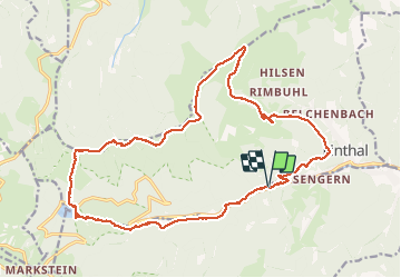

Length
21 km

Max alt
1320 m

Uphill gradient
1026 m
Km-Effort
35 km

Min alt
504 m

Downhill gradient
1021 m
Boucle
Yes
Creation date :
2020-10-20 07:02:27.996
Updated on :
2020-10-20 17:41:24.954
7h31
Difficulty : Difficult

FREE GPS app for hiking
 SityTrail
IGN / Geographical institutes
SityTrail Plus
The world is yours!
About
Trail Walking of 21 km to be discovered at Grand Est, Haut-Rhin, Lautenbachzell. This trail is proposed by gerard70.
Description
Lac de la lauch col hilsenfirst
Positioning
Country:
France
Region :
Grand Est
Department/Province :
Haut-Rhin
Municipality :
Lautenbachzell
Location:
Unknown
Start:(Dec)
Start:(UTM)
358488 ; 5311426 (32T) N.
Comments