


Col de Marocaz- La Thuile

Nicolas_Dec
User
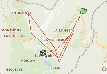

Length
11.7 km

Max alt
1271 m

Uphill gradient
1032 m
Km-Effort
26 km

Min alt
817 m

Downhill gradient
1117 m
Boucle
No
Creation date :
2020-10-25 09:47:01.93
Updated on :
2020-10-25 11:00:54.424
1h13
Difficulty : Very easy

FREE GPS app for hiking
 SityTrail
IGN / Geographical institutes
SityTrail Plus
The world is yours!
About
Trail Walking of 11.7 km to be discovered at Auvergne-Rhône-Alpes, Savoy, La Thuile. This trail is proposed by Nicolas_Dec.
Positioning
Country:
France
Region :
Auvergne-Rhône-Alpes
Department/Province :
Savoy
Municipality :
La Thuile
Location:
Unknown
Start:(Dec)
Start:(UTM)
271696 ; 5048057 (32T) N.
Comments