


Route des vignes - Bergheim

duchaine.nicolas
User
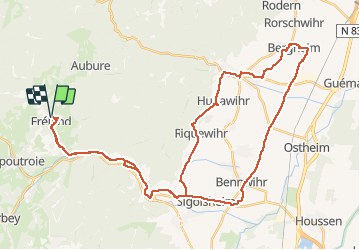

Length
48 km

Max alt
501 m

Uphill gradient
725 m
Km-Effort
57 km

Min alt
178 m

Downhill gradient
726 m
Boucle
Yes
Creation date :
2020-10-25 08:33:23.537
Updated on :
2020-10-25 12:18:17.425
3h33
Difficulty : Easy
3h33
Difficulty : Easy

FREE GPS app for hiking
 SityTrail
IGN / Geographical institutes
SityTrail Plus
The world is yours!
About
Trail Mountain bike of 48 km to be discovered at Grand Est, Haut-Rhin, Fréland. This trail is proposed by duchaine.nicolas.
Positioning
Country:
France
Region :
Grand Est
Department/Province :
Haut-Rhin
Municipality :
Fréland
Location:
Unknown
Start:(Dec)
Start:(UTM)
365791 ; 5337182 (32U) N.
Comments