


Arles sur Tech - Jacouti - Arles

patbt
User
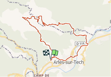

Length
11.3 km

Max alt
623 m

Uphill gradient
455 m
Km-Effort
17.3 km

Min alt
253 m

Downhill gradient
454 m
Boucle
Yes
Creation date :
2020-10-25 11:01:10.471
Updated on :
2020-10-25 16:28:35.47
5h24
Difficulty : Easy

FREE GPS app for hiking
 SityTrail
IGN / Geographical institutes
SityTrail Plus
The world is yours!
About
Trail Walking of 11.3 km to be discovered at Occitania, Pyrénées-Orientales, Arles-sur-Tech. This trail is proposed by patbt.
Positioning
Country:
France
Region :
Occitania
Department/Province :
Pyrénées-Orientales
Municipality :
Arles-sur-Tech
Location:
Unknown
Start:(Dec)
Start:(UTM)
469110 ; 4700608 (31T) N.
Comments