


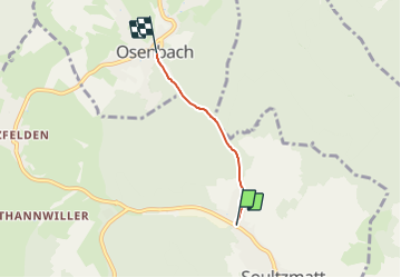
Montée d'Osenbach 2,4km

staubalex
User

Length
2.4 km

Max alt
382 m

Uphill gradient
108 m
Km-Effort
3.5 km

Min alt
273 m

Downhill gradient
0 m
Boucle
No
Creation date :
2014-12-10 00:00:00.0
Updated on :
2014-12-10 00:00:00.0
13m
Difficulty : Medium

FREE GPS app for hiking
 SityTrail
IGN / Geographical institutes
SityTrail Plus
The world is yours!
About
Trail Cycle of 2.4 km to be discovered at Grand Est, Haut-Rhin, Soultzmatt. This trail is proposed by staubalex.
Positioning
Country:
France
Region :
Grand Est
Department/Province :
Haut-Rhin
Municipality :
Soultzmatt
Location:
Unknown
Start:(Dec)
Start:(UTM)
368019 ; 5314200 (32T) N.
Comments