Trail Horseback riding Wingen - 2018-04-07 CRTE Alsace Loewenstein Hohenbourg Fleckenstein - Photo

2018-04-07 CRTE Alsace Loewenstein Hohenbourg Fleckenstein

Promouvoir le Tourisme Equestre en Alsace GUIDE+

© OpenStreetMap contributors
Length
Length
18.4 km
Max alt
Max alt
544 m
Uphill gradient
Uphill gradient
550 m
Km-Effort
Km-Effort  
26 km
Min alt
Min alt
268 m
Downhill gradient
Downhill gradient
550 m
Boucle
Boucle
Yes
Creation date :
2020-10-30 10:30:31.281
Updated on :
2021-03-19 14:36:26.905

(1 Reviews)

Horseback riding
Horseback riding
3h08
Difficulty : Medium

Scan this QR Code to open this trail in the SityTrail application

FREE GPS app for hiking

Logo SityTrail SityTrail

IGN / Geographical institutes

Download SityTrail from the App Store Download SityTrail from Google Play

Logo SityTrail SityTrail World

The world is yours!

Download SityTrail from the App Store Download SityTrail from Google Play Download SityTrail on Huawei AppGallery

About

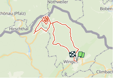
Trail Horseback riding of 18.4 km to be discovered at Grand Est, Bas-Rhin, Wingen. This trail is proposed by Tourisme Equestre Alsace.

Description

Boucle au départ et à l'arrivée de Wingen en passant par les châteaux du  Loewenstein, Hohenbourg, Fleckenstein et par l'auberge du Gimbelhof avec de nombreuses haltes équestres

Elevation profile

Photos

Points of interest

Point of interest Wingen - Château du Hohenbourg - Photo
Tourisme Equestre Alsace
Point of interest Lembach - Château du Fleckenstein - Photo
Tourisme Equestre Alsace
Point of interest Lembach - Gimbelhof - Photo
Tourisme Equestre Alsace
LEMBACH 
Point of interest Wingen - Départ et Arrivée - Photo
holtzv

Positioning

Country:
France
Region :
Grand Est
Department/Province :
Bas-Rhin
Municipality :
Wingen
Location:
Unknown
Start:(UTM)
413739 ; 5430955 (32U) N.

Comments

Please log in to post a review or rate the element


Belle randonnée, sans difficultés particulières. A partir de l'étang du Heimbach, le tracé prend la route forestière alors qu'il est possible de continuer sur le GR pour arriver au col du Litschhof. Le sentier qui descend du Hohenbourg vers le Fleckenstein est relativement raide mais praticable. Au col du Litschhof direction col du Riegelsberg, attention à ne pas rater le sentier croix rouge, le départ est bien caché par la végétation. On coupe ensuite une piste forestière qu'il faut suivre jusqu'au col du Riegelsberg. La piste forestière n'est pas du tout entretenue, mais ça passe ! Beaux chemins, nombreux points d'intérêt et beaux points de vue.


Trails nearby

Trail Walking Lembach - Fleckenstein, circuit des 5 châteaux. - Photo
Walking
mitch1915

Walking

Difficult
(1)
Lembach, Grand Est, Bas-Rhin, France
15.6 km | 25 km-effort
5h 6min
Yes
Trail Mountain bike Cleebourg - Petite sortie VTT sympa secteur Wissembourg - Photo
Mountain bike
tracegps

Mountain bike

Medium
(1)
Cleebourg, Grand Est, Bas-Rhin, France
23 km | 32 km-effort
2h 30min
Yes
Trail On foot Lembach - Anneau vert - Photo
On foot
PRO

On foot

Easy
Lembach, Grand Est, Bas-Rhin, France
3.8 km | 5.2 km-effort
1h 10min
Yes
Trail On foot Climbach - Triangle vert - Photo
On foot
PRO

On foot

Easy
Climbach, Grand Est, Bas-Rhin, France
10.3 km | 15 km-effort
3h 24min
No
Trail On foot Cleebourg - Disque jaune - Photo
On foot
PRO

On foot

Medium
Cleebourg, Grand Est, Bas-Rhin, France
20 km | 27 km-effort
6h 13min
No
Trail On foot Lembach - Rectangle bleu barré de blanc - Photo
On foot
PRO

On foot

Easy
Lembach, Grand Est, Bas-Rhin, France
4 km | 6 km-effort
1h 21min
No
Trail On foot Lembach - Anneau jaune - Photo
On foot
PRO

On foot

Easy
Lembach, Grand Est, Bas-Rhin, France
6.4 km | 9.3 km-effort
2h 6min
Yes
Trail On foot Wingen - Croix rouge - Photo
On foot
PRO

On foot

Easy
Wingen, Grand Est, Bas-Rhin, France
5.4 km | 7.4 km-effort
1h 41min
No
Trail On foot Lembach - Croix bleue - Photo
On foot
PRO

On foot

Easy
Lembach, Grand Est, Bas-Rhin, France
12.8 km | 18.4 km-effort
4h 10min
No


Close
My subscriptions