


TMB-J4

migouel
User
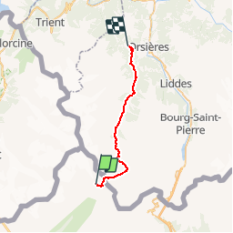

Length
25 km

Max alt
2532 m

Uphill gradient
1073 m
Km-Effort
41 km

Min alt
1050 m

Downhill gradient
1659 m
Boucle
No
Creation date :
2014-12-10 00:00:00.0
Updated on :
2014-12-10 00:00:00.0
5m
Difficulty : Difficult

FREE GPS app for hiking
 SityTrail
IGN / Geographical institutes
SityTrail Plus
The world is yours!
About
Trail Mountain bike of 25 km to be discovered at Aosta Valley, Unknown, Courmayeur. This trail is proposed by migouel.
Description
VTT TMB J4
Positioning
Country:
Italy
Region :
Aosta Valley
Department/Province :
Unknown
Municipality :
Courmayeur
Location:
Unknown
Start:(Dec)
Start:(UTM)
349957 ; 5083074 (32T) N.
Comments