


BRUNSTATT

jmbilger
User
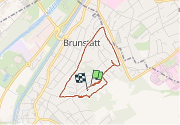

Length
3.6 km

Max alt
308 m

Uphill gradient
66 m
Km-Effort
4.5 km

Min alt
252 m

Downhill gradient
69 m
Boucle
Yes
Creation date :
2020-11-01 16:57:36.0
Updated on :
2020-11-01 17:48:25.523
49m
Difficulty : Unknown

FREE GPS app for hiking
 SityTrail
IGN / Geographical institutes
SityTrail Plus
The world is yours!
About
Trail Walking of 3.6 km to be discovered at Grand Est, Haut-Rhin, Brunstatt-Didenheim. This trail is proposed by jmbilger.
Positioning
Country:
France
Region :
Grand Est
Department/Province :
Haut-Rhin
Municipality :
Brunstatt-Didenheim
Location:
Brunstatt
Start:(Dec)
Start:(UTM)
374538 ; 5286865 (32T) N.
Comments