Trail Walking Champéry - Dent du Midi - Haute Cime - Photo

Dent du Midi - Haute Cime

 otrement
otrement

User

© OpenStreetMap contributors
Length
Length
9.9 km
Max alt
Max alt
3254 m
Uphill gradient
Uphill gradient
2158 m
Km-Effort
Km-Effort  
32 km
Min alt
Min alt
1126 m
Downhill gradient
Downhill gradient
65 m
Boucle
Boucle
No
Creation date :
2014-12-11 00:00:00.0
Updated on :
2014-12-11 00:00:00.0

(0 Reviews)

Walking
Walking
8h32
Difficulty : Unknown

Scan this QR Code to open this trail in the SityTrail application

FREE GPS app for hiking

Logo SityTrail SityTrail

IGN / Geographical institutes

Download SityTrail from the App Store Download SityTrail from Google Play

Logo SityTrail SityTrail World

The world is yours!

Download SityTrail from the App Store Download SityTrail from Google Play Download SityTrail on Huawei AppGallery

About

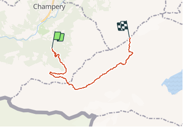
Trail Walking of 9.9 km to be discovered at Valais/Wallis, Monthey, Champéry. This trail is proposed by otrement.

Description

Au départ du Grand Paradis, monter à la Cabane de Susanfe par le Pas d''Encel Puis direction le Col de Susanfe avant d''attaquer la montée raide direction le sommet. La partie du haut et franchement raide. La descente peut s''effectuer directement sous le sommet en direction de la cabane. La montée peut être coupée en deux en prévoyant une nuit à la cabane.

Elevation profile

Points of interest

Point of interest Evionnaz - Col de Susanfe - Photo
otrement
EVIONNAZ 
Point of interest Evionnaz - Cabane de Susanfe - Photo
otrement
Point of interest Champéry - Pas d'Encel - Photo
otrement
CHAMPÉRY 
Point of interest Champéry - Grand Paradis - Photo
otrement
CHAMPÉRY 
Point of interest Val-d'Illiez - Haute Cime - Photo
otrement
VAL-D'ILLIEZ 

Positioning

Country:
Switzerland
Region :
Valais/Wallis
Department/Province :
Monthey
Municipality :
Champéry
Location:
Unknown
Start:(UTM)
335600 ; 5113611 (32T) N.

Trails nearby

Trail On foot Val-d'Illiez - Les Crosets-Sur Cou - Photo
On foot
PRO

On foot

Easy
Val-d'Illiez, Valais/Wallis, Monthey, Switzerland
3.6 km | 4.8 km-effort
1h 6min
No
Trail Walking Val-d'Illiez - Dents de Midi, Lac de Soi - Photo
Walking
rpf

Walking

Very easy
(1)
Val-d'Illiez, Valais/Wallis, Monthey, Switzerland
5.1 km | 9.8 km-effort
2h 30min
Yes
Trail Walking Champéry - Champéry - Die Galérie Défago - Photo
Walking
otchampery

Walking

Very easy
(1)
Champéry, Valais/Wallis, Monthey, Switzerland
10.1 km | 15 km-effort
3h 38min
No
Trail On foot Sixt-Fer-à-Cheval - GR de Pays Tour des Dents Blanches - Photo
On foot
PRO

On foot

Very difficult
Sixt-Fer-à-Cheval, Auvergne-Rhône-Alpes, Upper Savoy, France
41 km | 87 km-effort
19h 51min
Yes
Trail Walking Val-d'Illiez - Lac de Soi - Photo
Walking
bozo1970

Walking

Very difficult
Val-d'Illiez, Valais/Wallis, Monthey, Switzerland
14.6 km | 30 km-effort
5h 19min
Yes
Trail Walking Val-d'Illiez - lac de soi par signal de soi - Photo
Walking
ajpbm

Walking

Difficult
Val-d'Illiez, Valais/Wallis, Monthey, Switzerland
10.4 km | 25 km-effort
4h 5min
Yes
Trail Other activity Samoëns - bdx004_0626 - Photo
Other activity
GUIDE+

Other activity

Very easy
Samoëns, Auvergne-Rhône-Alpes, Upper Savoy, France
23 km | 54 km-effort
13h 34min
No
Trail Walking Champéry - hike33 - Photo
Walking
GUIDE+

Walking

Very easy
Champéry, Valais/Wallis, Monthey, Switzerland
9.1 km | 15.9 km-effort
Unknown
No
Trail Walking Champéry - vs_hike808c - Photo
Walking
GUIDE+

Walking

Very easy
Champéry, Valais/Wallis, Monthey, Switzerland
102 km | 194 km-effort
36h 47min
Yes


Close
My subscriptions