Trail Mountain bike Blonay - Le tour du Cubly depuis Blonay - Photo
 otrement
otrement

User

© OpenStreetMap contributors
Length
Length
22 km
Max alt
Max alt
1206 m
Uphill gradient
Uphill gradient
1178 m
Km-Effort
Km-Effort  
38 km
Min alt
Min alt
554 m
Downhill gradient
Downhill gradient
1182 m
Boucle
Boucle
Yes
Creation date :
2014-12-11 00:00:00.0
Updated on :
2014-12-11 00:00:00.0

(0 Reviews)

Mountain bike
Mountain bike
2h51
Difficulty : Unknown

Scan this QR Code to open this trail in the SityTrail application

FREE GPS app for hiking

Logo SityTrail SityTrail

IGN / Geographical institutes

Download SityTrail from the App Store Download SityTrail from Google Play

Logo SityTrail SityTrail World

The world is yours!

Download SityTrail from the App Store Download SityTrail from Google Play Download SityTrail on Huawei AppGallery

About

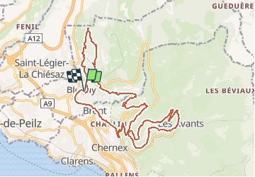
Trail Mountain bike of 22 km to be discovered at Vaud, District de la Riviera-Pays-d’Enhaut, Blonay. This trail is proposed by otrement.

Description

Au départ de Blonay nous montons sur les Chevalleyres par la route puis sur un chemin carrossable. A la deuxième épingle, c''est parti pour la traversée à mi hauteur jusqu''au Sex que Pillau principalement en single, splendide! La montée du mytique chemin romain laisse des traces. Celui-ci nous permait d''accéder à Cubly Dessous. De là nous empruntons à nouveau des singles jusqu''à la gare des Avants. Une montée par la route sur Sonloup puis c''est l''arrête du Cubly avant d''entammer la descente sur Chamby par le sentier des 22 contours. Retour à Blonay par la route principale.

Elevation profile

Points of interest

Point of interest Montreux - Sex que Plliau - Photo
otrement
MONTREUX 
Point of interest Montreux - Chaulin - Photo
otrement
MONTREUX 
Point of interest Montreux - Sonloup - Photo
otrement
MONTREUX 
Point of interest Montreux - Le Montagnard - Photo
otrement
MONTREUX 
Point of interest Blonay - Le Signal - Photo
otrement
BLONAY 
Point of interest Blonay - Blonay Gare - Photo
otrement
BLONAY 

Positioning

Country:
Switzerland
Region :
Vaud
Department/Province :
District de la Riviera-Pays-d’Enhaut
Municipality :
Blonay
Location:
Unknown
Start:(UTM)
338525 ; 5147789 (32T) N.

Trails nearby

Trail Walking Montreux - Montreux - Villeneuve - Le Bouveret - Photo
Walking
GUIDE+

Walking

Very easy
(1)
Montreux, Vaud, District de la Riviera-Pays-d’Enhaut, Switzerland
14.5 km | 16.4 km-effort
Unknown
No
Trail On foot Montreux - Sentier des Narcisses - Photo
On foot
PRO

On foot

Easy
Montreux, Vaud, District de la Riviera-Pays-d’Enhaut, Switzerland
5.4 km | 9.8 km-effort
2h 13min
Yes
Trail Cycle Vevey - Vevey - Nyon - Photo
Cycle
karawatsj

Cycle

Difficult
Vevey, Vaud, District de la Riviera-Pays-d’Enhaut, Switzerland
70 km | 82 km-effort
7h 11min
No
Trail Cycle La Tour-de-Peilz - Vom Genfersee an den Bodensee - Photo
Cycle
GUIDE+

Cycle

Very easy
La Tour-de-Peilz, Vaud, District de la Riviera-Pays-d’Enhaut, Switzerland
302 km | 466 km-effort
123h 6min
No
Trail Mountain bike Blonay - Les Pléiades - Photo
Mountain bike
GUIDE+

Mountain bike

Very easy
Blonay, Vaud, District de la Riviera-Pays-d’Enhaut, Switzerland
35 km | 44 km-effort
11h 26min
No
Trail Walking La Tour-de-Peilz - st_korea_tv1 - Photo
Walking
GUIDE+

Walking

Very easy
La Tour-de-Peilz, Vaud, District de la Riviera-Pays-d’Enhaut, Switzerland
428 km | 1002 km-effort
29h 5min
No
Trail Walking La Tour-de-Peilz - st_ral_08_5 - Photo
Walking
GUIDE+

Walking

Very easy
La Tour-de-Peilz, Vaud, District de la Riviera-Pays-d’Enhaut, Switzerland
116 km | 154 km-effort
6h 55min
No
Trail Nordic walking Chardonne - plein ciel  - Photo
Nordic walking
suzanne.bron

Nordic walking

Very easy
Chardonne, Vaud, District de la Riviera-Pays-d’Enhaut, Switzerland
6.2 km | 9.9 km-effort
2h 16min
Yes
Trail On foot Montreux - Les Gorges du Chauderon - Photo
On foot
famiski

On foot

Easy
Montreux, Vaud, District de la Riviera-Pays-d’Enhaut, Switzerland
6.7 km | 11.8 km-effort
2h 40min
Yes


Close
My subscriptions