


les mulets par le lac d ibardin

yoye
User
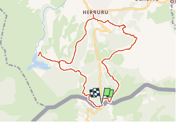

Length
12 km

Max alt
383 m

Uphill gradient
444 m
Km-Effort
17.9 km

Min alt
87 m

Downhill gradient
445 m
Boucle
Yes
Creation date :
2020-11-12 16:44:51.602
Updated on :
2020-11-12 16:47:41.441
3h45
Difficulty : Easy

FREE GPS app for hiking
 SityTrail
IGN / Geographical institutes
SityTrail Plus
The world is yours!
About
Trail On foot of 12 km to be discovered at New Aquitaine, Pyrénées-Atlantiques, Urrugne. This trail is proposed by yoye.
Description
facile
Positioning
Country:
France
Region :
New Aquitaine
Department/Province :
Pyrénées-Atlantiques
Municipality :
Urrugne
Location:
Unknown
Start:(Dec)
Start:(UTM)
606679 ; 4796102 (30T) N.
Comments