


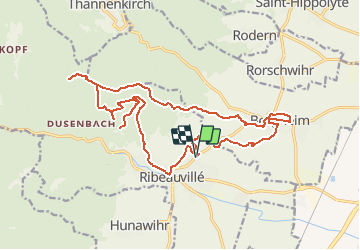
SityTrail - 2015-04-26 Picnic CVA Ribeauville

Tourisme Equestre Alsace
Promouvoir le Tourisme Equestre en Alsace GUIDE+


3h43
Difficulty : Medium

FREE GPS app for hiking
 SityTrail
IGN / Geographical institutes
SityTrail Plus
The world is yours!
About
Trail Horseback riding of 21 km to be discovered at Grand Est, Haut-Rhin, Ribeauvillé. This trail is proposed by Tourisme Equestre Alsace.
Description
Boucle au départ et à l'arrivée de Ribeauvillé en passant par les villages de Bergheim et Ribeauvillé (merci de ramasser vos crottins en passant), l'abri du Taennchel et les châteaux de Ribeauvillé (le Haut-Ribeaupierre, le Saint-Ulrich et le Girsberg avec une barre d'attache à ce dernier)
Photos


Positioning
Comments