Trail Walking Sint-Laureins - Sint-Margriete 23 km - Photo
 rvapeldo
rvapeldo

User GUIDE

© OpenStreetMap contributors
Length
Length
23 km
Max alt
Max alt
5 m
Uphill gradient
Uphill gradient
37 m
Km-Effort
Km-Effort  
23 km
Min alt
Min alt
-3 m
Downhill gradient
Downhill gradient
37 m
Boucle
Boucle
Yes
Creation date :
2020-11-14 10:27:12.0
Updated on :
2020-11-15 07:51:14.482

(0 Reviews)

Walking
Walking
5h20
Difficulty : Easy

Scan this QR Code to open this trail in the SityTrail application

FREE GPS app for hiking

Logo SityTrail SityTrail

IGN / Geographical institutes

Download SityTrail from the App Store Download SityTrail from Google Play

Logo SityTrail SityTrail World

The world is yours!

Download SityTrail from the App Store Download SityTrail from Google Play Download SityTrail on Huawei AppGallery

About

Trail Walking of 23 km to be discovered at Flanders, East Flanders, Sint-Laureins. This trail is proposed by rvapeldo.

Description

Parcours dans la Flandre zélandaise, en majeure partie aux Pays-Bas, sur des chemins agricoles (parfois fort boueux en ce mois de novembre). Le trajet passe devant de nombreuses bornes frontières coniques issues du traité des frontières de 1843.
Route in Zeeuws-Vlaanderen, voornamelijk in Nederland, over landbouwpaden (soms erg modderig in november).  De route loopt langs talrijke kegelvormige grenspalen als gevolg van het grensverdrag van 1843.

Elevation profile

Photos

Positioning

Country:
Belgium
Region :
Flanders
Department/Province :
East Flanders
Municipality :
Sint-Laureins
Location:
Sint-Margriete
Start:(UTM)
538179 ; 5681153 (31U) N.

Trails nearby

Trail Walking Sint-Laureins - St Magriete GR - Photo
Walking
elsdewilde

Walking

Very easy
Sint-Laureins, Flanders, East Flanders, Belgium
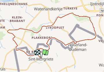
30 km | 31 km-effort
Unknown
No
Trail Cycle Sluis - f-zeeland-vrijedijkroute - Photo
Cycle
gpstracks

Cycle

Very easy
Sluis, Zeeland, Unknown, Netherlands
26 km | 27 km-effort
Unknown
Yes
Trail Cycle Sluis - f-zeeland-ijzendijke-st-kruis-st-laurens - Photo
Cycle
gpstracks

Cycle

Very easy
Sluis, Zeeland, Unknown, Netherlands
54 km | 56 km-effort
Unknown
Yes
Trail Cycle Sluis - f-zeeland-ijzendijke-cadzand - Photo
Cycle
gpstracks

Cycle

Very easy
Sluis, Zeeland, Unknown, Netherlands
62 km | 64 km-effort
Unknown
Yes
Trail Walking Sluis - w-zeeland-sint-kruis-sint-laurens - Photo
Walking
gpstracks

Walking

Very easy
Sluis, Zeeland, Unknown, Netherlands
25 km | 26 km-effort
Unknown
Yes
Trail Walking Sluis - w-zeeland-rondje-ijzendijke - Photo
Walking
gpstracks

Walking

Very easy
Sluis, Zeeland, Unknown, Netherlands
19.8 km | 20 km-effort
Unknown
Yes
Trail Walking Sluis - w-zeeland-ijzendijke-rondje - Photo
Walking
gpstracks

Walking

Very easy
Sluis, Zeeland, Unknown, Netherlands
7.7 km | 7.9 km-effort
Unknown
Yes
Trail Walking Sint-Laureins - Sint-Laureins door de Polder - 9 km RT - Photo
Walking
wandelroutes

Walking

Very easy
Sint-Laureins, Flanders, East Flanders, Belgium
8.8 km | 9.1 km-effort
Unknown
Yes
Trail Cycle Sint-Laureins - Fietsroute langs polders en kreken - Photo
Cycle
zorro

Cycle

Medium
Sint-Laureins, Flanders, East Flanders, Belgium
37 km | 38 km-effort
2h 18min
Yes


Close
My subscriptions