


Nonnenbruch 01

selevrich
User
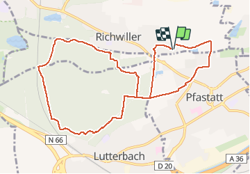

Length
10.9 km

Max alt
263 m

Uphill gradient
88 m
Km-Effort
12 km

Min alt
235 m

Downhill gradient
88 m
Boucle
Yes
Creation date :
2020-11-22 07:58:08.763
Updated on :
2020-11-22 09:54:59.88
1h55
Difficulty : Very easy

FREE GPS app for hiking
 SityTrail
IGN / Geographical institutes
SityTrail Plus
The world is yours!
About
Trail Walking of 10.9 km to be discovered at Grand Est, Haut-Rhin, Richwiller. This trail is proposed by selevrich.
Positioning
Country:
France
Region :
Grand Est
Department/Province :
Haut-Rhin
Municipality :
Richwiller
Location:
Unknown
Start:(Dec)
Start:(UTM)
372258 ; 5293012 (32T) N.
Comments