


Rochehaut échelle

michelcortvrint
User
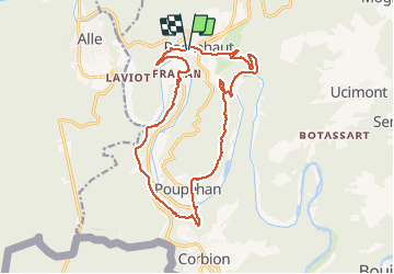

Length
16.5 km

Max alt
374 m

Uphill gradient
635 m
Km-Effort
25 km

Min alt
194 m

Downhill gradient
639 m
Boucle
Yes
Creation date :
2020-12-04 09:01:52.0
Updated on :
2020-12-04 15:23:10.789
4h53
Difficulty : Medium

FREE GPS app for hiking
 SityTrail
IGN / Geographical institutes
SityTrail Plus
The world is yours!
About
Trail Walking of 16.5 km to be discovered at Wallonia, Luxembourg, Bouillon. This trail is proposed by michelcortvrint.
Positioning
Country:
Belgium
Region :
Wallonia
Department/Province :
Luxembourg
Municipality :
Bouillon
Location:
Rochehaut
Start:(Dec)
Start:(UTM)
644097 ; 5522745 (31U) N.
Comments