Trail Walking Saint-Pierre-de-Chignac - St Pierre Chignac 14-18 km - Photo
 YV24
YV24

User

© OpenStreetMap contributors
Length
Length
14 km
Max alt
Max alt
233 m
Uphill gradient
Uphill gradient
298 m
Km-Effort
Km-Effort  
18 km
Min alt
Min alt
132 m
Downhill gradient
Downhill gradient
296 m
Boucle
Boucle
Yes
Creation date :
2016-06-25 00:00:00.0
Updated on :
2023-08-15 15:51:56.642

(0 Reviews)

Walking
Walking
3h52
Difficulty : Easy

Scan this QR Code to open this trail in the SityTrail application

FREE GPS app for hiking

Logo SityTrail SityTrail

IGN / Geographical institutes

Download SityTrail from the App Store Download SityTrail from Google Play

Logo SityTrail SityTrail World

The world is yours!

Download SityTrail from the App Store Download SityTrail from Google Play Download SityTrail on Huawei AppGallery

About

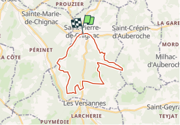
Trail Walking of 14 km to be discovered at New Aquitaine, Dordogne, Saint-Pierre-de-Chignac. This trail is proposed by YV24.

Description

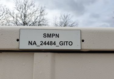
Selon PDIPR n°14 carte de St Pierre de Chignac.
Visite intéressante des chais sur RDV.
Possibilité de pique-nique au bord de l'étang du Manoire, 1km à l'est du bourg, en longeant la voie ferrée

Elevation profile

Positioning

Country:
France
Region :
New Aquitaine
Department/Province :
Dordogne
Municipality :
Saint-Pierre-de-Chignac
Location:
Unknown
Start:(UTM)
331449 ; 4998982 (31T) N.

Trails nearby

Trail On foot Saint-Pierre-de-Chignac - Boucle du Lavoir - Photo
On foot
PRO

On foot

Easy
Saint-Pierre-de-Chignac, New Aquitaine, Dordogne, France
5.3 km | 7.1 km-effort
1h 37min
Yes
Trail On foot Saint-Pierre-de-Chignac - Boucle de la Chapelle - Photo
On foot
PRO

On foot

Easy
Saint-Pierre-de-Chignac, New Aquitaine, Dordogne, France
14.7 km | 18.7 km-effort
4h 14min
No
Trail Walking Saint-Pierre-de-Chignac - boucle chai lamardie - Photo
Walking
fab0202

Walking

Easy
Saint-Pierre-de-Chignac, New Aquitaine, Dordogne, France
8.6 km | 11 km-effort
2h 45min
Yes
Trail On foot Saint-Crépin-d'Auberoche - Boucle de la Tuillère - Photo
On foot
PRO

On foot

Easy
(1)
Saint-Crépin-d'Auberoche, New Aquitaine, Dordogne, France
7.6 km | 9.5 km-effort
2h 9min
Yes
Trail On foot Saint-Crépin-d'Auberoche - Boucle de la Tuillère (Variante courte) - Photo
On foot
PRO

On foot

Easy
Saint-Crépin-d'Auberoche, New Aquitaine, Dordogne, France
5.2 km | 6.8 km-effort
1h 33min
Yes
Trail Walking Boulazac Isle Manoire - Saint Laurent sur Manoire - Photo
Walking
CC.RIDER

Walking

Difficult
(1)
Boulazac Isle Manoire, New Aquitaine, Dordogne, France
11.2 km | 14.1 km-effort
3h 12min
Yes
Trail Walking Saint-Geyrac - Boucle de la Forêt - Photo
Walking
CC.RIDER

Walking

Difficult
Saint-Geyrac, New Aquitaine, Dordogne, France
13.1 km | 16.6 km-effort
3h 46min
Yes
Trail Walking Bassillac et Auberoche - Eyliac Milpas - Photo
Walking
pascalmilpas

Walking

Difficult
Bassillac et Auberoche, New Aquitaine, Dordogne, France
12.4 km | 15.8 km-effort
3h 2min
Yes
Trail Walking Saint-Pierre-de-Chignac - Lardimalie, chai, chateau, le puy - Photo
Walking
jcc24

Walking

Easy
(2)
Saint-Pierre-de-Chignac, New Aquitaine, Dordogne, France
8.9 km | 11.3 km-effort
2h 20min
Yes


Close
My subscriptions