


VANOISE -orgere polset lac de la partie orgère

m261212
User
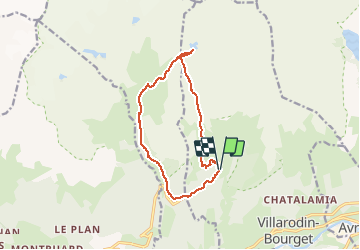

Length
11.9 km

Max alt
2503 m

Uphill gradient
767 m
Km-Effort
22 km

Min alt
1824 m

Downhill gradient
737 m
Boucle
Yes
Creation date :
2020-12-09 16:09:42.139
Updated on :
2020-12-09 16:10:14.344
4h26
Difficulty : Very difficult

FREE GPS app for hiking
 SityTrail
IGN / Geographical institutes
SityTrail Plus
The world is yours!
About
Trail Walking of 11.9 km to be discovered at Auvergne-Rhône-Alpes, Savoy, Villarodin-Bourget. This trail is proposed by m261212.
Positioning
Country:
France
Region :
Auvergne-Rhône-Alpes
Department/Province :
Savoy
Municipality :
Villarodin-Bourget
Location:
Unknown
Start:(Dec)
Start:(UTM)
317278 ; 5011012 (32T) N.
Comments