Trail Other activity Golbey - Circuit des tunnels - Photo

Circuit des tunnels

© OpenStreetMap contributors
Length
Length
32 km
Max alt
Max alt
475 m
Uphill gradient
Uphill gradient
453 m
Km-Effort
Km-Effort  
38 km
Min alt
Min alt
345 m
Downhill gradient
Downhill gradient
460 m
Boucle
Boucle
Yes
Creation date :
2014-12-10 00:00:00.0
Updated on :
2014-12-10 00:00:00.0

(0 Reviews)

Other activity
Other activity
3h00
Difficulty : Unknown

Scan this QR Code to open this trail in the SityTrail application

FREE GPS app for hiking

Logo SityTrail SityTrail

IGN / Geographical institutes

Download SityTrail from the App Store Download SityTrail from Google Play

Logo SityTrail SityTrail World

The world is yours!

Download SityTrail from the App Store Download SityTrail from Google Play Download SityTrail on Huawei AppGallery

About

Trail Other activity of 32 km to be discovered at Grand Est, Vosges, Golbey. This trail is proposed by fortiffsere.

Description

Sortie Velo le 30 03 2014

Elevation profile

Points of interest

Point of interest Chantraine - Magasin Central de bois le Duc - Photo
fortiffsere
Point of interest Les Forges - Magasin de secteur d'olima - Photo
fortiffsere
Point of interest Les Forges - Tunnel de Voie de 60 - Photo
fortiffsere
Point of interest Girancourt - Batterie D du théiha - Photo
fortiffsere
Point of interest Girancourt - Réduuit du Thiéha - Photo
fortiffsere
Point of interest Girancourt - Tunnel du Thiéha - Photo
fortiffsere
GIRANCOURT 
Point of interest Renauvoid - Poste de commandement du secteur Sud-ouest de la place forte - Photo
fortiffsere
Point of interest Renauvoid - Passage de la voie de 60 - Photo
fortiffsere
Point of interest Girancourt - Aire de jeu - Photo
fortiffsere
GIRANCOURT 
Point of interest Sanchey - Batterie de Sanchey - Photo
fortiffsere
Point of interest Les Forges - Batterie d'artillerie M36 des forges - Photo
fortiffsere

Positioning

Country:
France
Region :
Grand Est
Department/Province :
Vosges
Municipality :
Golbey
Location:
Unknown
Start:(UTM)
308178 ; 5340469 (32U) N.

Trails nearby

Trail sport Épinal - Golbey - Photo
sport
lebregien

sport

Very easy
(1)
Épinal, Grand Est, Vosges, France
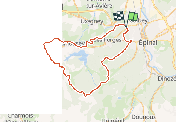
7.1 km | 7.8 km-effort
Unknown
Yes
Trail Walking Épinal - Epinal - Photo
Walking
FOUCAULT

Walking

Épinal, Grand Est, Vosges, France
9.3 km | 10.7 km-effort
3h 0min
Yes
Trail Road bike Épinal - epinal florémont bouxières - Photo
Road bike
GuySimonin

Road bike

Medium
(1)
Épinal, Grand Est, Vosges, France
93 km | 110 km-effort
6h 26min
Yes
Trail Walking Épinal - ste Barbe - Photo
Walking
BernardHumeau

Walking

Very easy
Épinal, Grand Est, Vosges, France
6.7 km | 9 km-effort
1h 55min
Yes
Trail Walking Épinal - 2016 03 22 - Photo
Walking
michelbauby

Walking

Easy
Épinal, Grand Est, Vosges, France
8.9 km | 12.4 km-effort
3h 8min
Yes
Trail Other activity Épinal - Grand Est - Ligne 18 - Epinal St Diè - Photo
Other activity
mich54

Other activity

Very easy
Épinal, Grand Est, Vosges, France
61 km | 68 km-effort
5min
No
Trail Other activity Épinal - Grand Est - Ligne 18,7 - Epinal Remiremont - Photo
Other activity
mich54

Other activity

Very easy
Épinal, Grand Est, Vosges, France
27 km | 31 km-effort
5min
No
Trail Walking Chantraine - De Chantraine à Bouzey - Photo
Walking
jeanclaude12

Walking

Easy
Chantraine, Grand Est, Vosges, France
14.6 km | 18.2 km-effort
3h 47min
Yes
Trail Walking Sanchey - A la Découverte de BOUZEY - Photo
Walking
jeanclaude12

Walking

Very easy
Sanchey, Grand Est, Vosges, France
7.7 km | 9.3 km-effort
2h 4min
Yes


Close
My subscriptions