


2020 12 Husseren Osenbach

staubalex
User
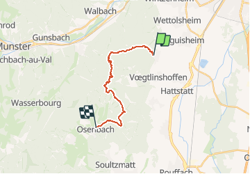

Length
15.3 km

Max alt
891 m

Uphill gradient
649 m
Km-Effort
24 km

Min alt
382 m

Downhill gradient
686 m
Boucle
No
Creation date :
2020-12-26 16:10:57.521
Updated on :
2020-12-26 16:12:48.094
4h57
Difficulty : Very difficult

FREE GPS app for hiking
 SityTrail
IGN / Geographical institutes
SityTrail Plus
The world is yours!
About
Trail Walking of 15.3 km to be discovered at Grand Est, Haut-Rhin, Husseren-les-Châteaux. This trail is proposed by staubalex.
Positioning
Country:
France
Region :
Grand Est
Department/Province :
Haut-Rhin
Municipality :
Husseren-les-Châteaux
Location:
Unknown
Start:(Dec)
Start:(UTM)
371554 ; 5321597 (32U) N.
Comments