


trace-5328-route

topolino
User
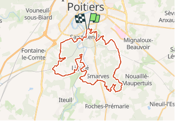

Length
41 km

Max alt
146 m

Uphill gradient
631 m
Km-Effort
50 km

Min alt
74 m

Downhill gradient
632 m
Boucle
Yes
Creation date :
2021-01-06 13:46:09.922
Updated on :
2021-01-06 13:49:37.009
--
Difficulty : Difficult

FREE GPS app for hiking
 SityTrail
IGN / Geographical institutes
SityTrail Plus
The world is yours!
About
Trail Mountain bike of 41 km to be discovered at New Aquitaine, Vienne, Saint-Benoît. This trail is proposed by topolino.
Positioning
Country:
France
Region :
New Aquitaine
Department/Province :
Vienne
Municipality :
Saint-Benoît
Location:
Unknown
Start:(Dec)
Start:(UTM)
296422 ; 5159488 (31T) N.
Comments