


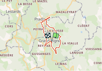
Grandsaigne_cascade de la Tine

viam19
User

Length
11.4 km

Max alt
765 m

Uphill gradient
361 m
Km-Effort
16.2 km

Min alt
565 m

Downhill gradient
361 m
Boucle
Yes
Creation date :
2021-01-08 22:09:36.012
Updated on :
2021-01-08 22:52:17.245
3h09
Difficulty : Difficult

FREE GPS app for hiking
 SityTrail
IGN / Geographical institutes
SityTrail Plus
The world is yours!
About
Trail Walking of 11.4 km to be discovered at New Aquitaine, Corrèze, Grandsaigne. This trail is proposed by viam19.
Positioning
Country:
France
Region :
New Aquitaine
Department/Province :
Corrèze
Municipality :
Grandsaigne
Location:
Unknown
Start:(Dec)
Start:(UTM)
415692 ; 5037849 (31T) N.
Comments