


adarre

Patox
User

Length
7.9 km

Max alt
576 m

Uphill gradient
494 m
Km-Effort
14.5 km

Min alt
124 m

Downhill gradient
495 m
Boucle
Yes
Creation date :
2021-01-13 12:07:09.176
Updated on :
2021-01-13 14:13:50.256
1h57
Difficulty : Very easy

FREE GPS app for hiking
 SityTrail
IGN / Geographical institutes
SityTrail Plus
The world is yours!
About
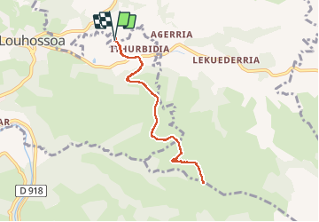
Trail Trail of 7.9 km to be discovered at New Aquitaine, Pyrénées-Atlantiques, Macaye. This trail is proposed by Patox.
Positioning
Country:
France
Region :
New Aquitaine
Department/Province :
Pyrénées-Atlantiques
Municipality :
Macaye
Location:
Unknown
Start:(Dec)
Start:(UTM)
635058 ; 4797292 (30T) N.
Comments