


charentes Dirac 48km 550m

topolino
User
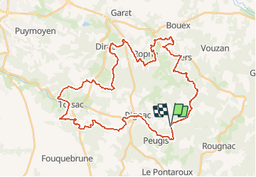

Length
47 km

Max alt
227 m

Uphill gradient
835 m
Km-Effort
58 km

Min alt
81 m

Downhill gradient
836 m
Boucle
Yes
Creation date :
2021-01-14 17:42:47.78
Updated on :
2021-01-14 17:42:47.78
--
Difficulty : Unknown

FREE GPS app for hiking
 SityTrail
IGN / Geographical institutes
SityTrail Plus
The world is yours!
About
Trail Mountain bike of 47 km to be discovered at New Aquitaine, Charente, Dignac. This trail is proposed by topolino.
Positioning
Country:
France
Region :
New Aquitaine
Department/Province :
Charente
Municipality :
Dignac
Location:
Unknown
Start:(Dec)
Start:(UTM)
290166 ; 5047474 (31T) N.
Comments