


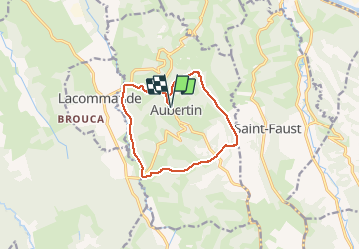
Aubertin G3

LouisROGER
User GUIDE

Length
12.1 km

Max alt
342 m

Uphill gradient
382 m
Km-Effort
17.2 km

Min alt
150 m

Downhill gradient
382 m
Boucle
Yes
Creation date :
2021-01-15 09:11:57.01
Updated on :
2021-01-15 19:22:28.184
5h05
Difficulty : Very easy

FREE GPS app for hiking
 SityTrail
IGN / Geographical institutes
SityTrail Plus
The world is yours!
About
Trail Walking of 12.1 km to be discovered at New Aquitaine, Pyrénées-Atlantiques, Aubertin. This trail is proposed by LouisROGER.
Positioning
Country:
France
Region :
New Aquitaine
Department/Province :
Pyrénées-Atlantiques
Municipality :
Aubertin
Location:
Unknown
Start:(Dec)
Start:(UTM)
704158 ; 4794445 (30T) N.
Comments