


Cépié

Ada11
User GUIDE
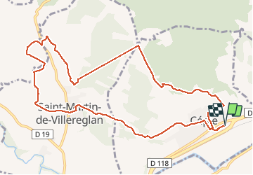

Length
12.9 km

Max alt
304 m

Uphill gradient
291 m
Km-Effort
16.8 km

Min alt
150 m

Downhill gradient
291 m
Boucle
Yes
Creation date :
2021-01-16 12:45:44.9
Updated on :
2021-02-26 18:47:51.178
2h34
Difficulty : Very easy

FREE GPS app for hiking
 SityTrail
IGN / Geographical institutes
SityTrail Plus
The world is yours!
About
Trail Walking of 12.9 km to be discovered at Occitania, Aude, Cépie. This trail is proposed by Ada11.
Description
Beaucoup de chemin, macadam.
Un morceau de carte manquant.
Photos


Positioning
Country:
France
Region :
Occitania
Department/Province :
Aude
Municipality :
Cépie
Location:
Unknown
Start:(Dec)
Start:(UTM)
438866 ; 4772628 (31T) N.
Comments