Trail Walking Cépie - Cépié - Photo
 Ada11
Ada11

User GUIDE

© OpenStreetMap contributors
Length
Length
12.9 km
Max alt
Max alt
304 m
Uphill gradient
Uphill gradient
291 m
Km-Effort
Km-Effort  
16.8 km
Min alt
Min alt
150 m
Downhill gradient
Downhill gradient
291 m
Boucle
Boucle
Yes
Creation date :
2021-01-16 12:45:44.9
Updated on :
2021-02-26 18:47:51.178

(0 Reviews)

Walking
Walking
2h34
Difficulty : Very easy

Scan this QR Code to open this trail in the SityTrail application

FREE GPS app for hiking

Logo SityTrail SityTrail

IGN / Geographical institutes

Download SityTrail from the App Store Download SityTrail from Google Play

Logo SityTrail SityTrail World

The world is yours!

Download SityTrail from the App Store Download SityTrail from Google Play Download SityTrail on Huawei AppGallery

About

Trail Walking of 12.9 km to be discovered at Occitania, Aude, Cépie. This trail is proposed by Ada11.

Description

Beaucoup de chemin, macadam.
Un morceau de carte manquant.

Elevation profile

Photos

Positioning

Country:
France
Region :
Occitania
Department/Province :
Aude
Municipality :
Cépie
Location:
Unknown
Start:(UTM)
438866 ; 4772628 (31T) N.

Trails nearby

Trail Walking Saint-Martin-de-Villereglan - rando saint Martin de villereglan - Photo
Walking
Mamilaure

Walking

Easy
(1)
Saint-Martin-de-Villereglan, Occitania, Aude, France
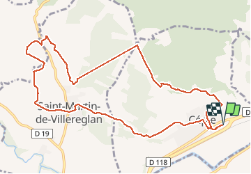
10.7 km | 13.5 km-effort
2h 23min
Yes
Trail Mountain bike Montclar - VTT à Arnauteille - Montclar - Photo
Mountain bike
tracegps

Mountain bike

Difficult
(3)
Montclar, Occitania, Aude, France
21 km | 28 km-effort
1h 40min
Yes
Trail Walking Preixan - preixan - Photo
Walking
Mascart

Walking

Very easy
(1)
Preixan, Occitania, Aude, France
9.1 km | 12.1 km-effort
2h 42min
Yes
Trail On foot Saint-Hilaire - Boucle de Saint-Hilaire - Photo
On foot
PRO

On foot

Easy
Saint-Hilaire, Occitania, Aude, France
7.3 km | 9.5 km-effort
2h 9min
Yes
Trail Walking Saint-Hilaire - Boucle de Saint-Hilaire - Photo
Walking
PI11

Walking

Medium
(1)
Saint-Hilaire, Occitania, Aude, France
8.8 km | 11.2 km-effort
2h 32min
Yes
Trail Mountain bike Limoux - Limoux, toureille, croix st Pierre   - Photo
Mountain bike
schwarzy

Mountain bike

Difficult
Limoux, Occitania, Aude, France
30 km | 42 km-effort
4h 41min
Yes
Trail Walking Villarzel-du-Razès - Rec Grand - Villarzel du Razès - Photo
Walking
Taricot

Walking

Medium
Villarzel-du-Razès, Occitania, Aude, France
9.5 km | 12.6 km-effort
3h 0min
Yes
Trail Walking Villarzel-du-Razès - Rec Grand - Villarzel du Razès - Photo
Walking
tracegps

Walking

Medium
(1)
Villarzel-du-Razès, Occitania, Aude, France
9.5 km | 12.6 km-effort
3h 0min
Yes
Trail Mountain bike Pieusse - Los camins de la blanqueta 2006 - Photo
Mountain bike
tracegps

Mountain bike

Very difficult
Pieusse, Occitania, Aude, France
53 km | 71 km-effort
4h 30min
Yes


Close
My subscriptions