


Sortie_vtt_For_t_de_Saint_Sauvant_

topolino
User

Length
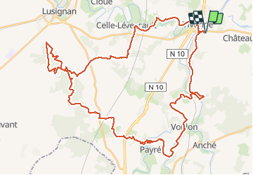
59 km

Max alt
178 m

Uphill gradient
596 m
Km-Effort
67 km

Min alt
88 m

Downhill gradient
596 m
Boucle
Yes
Creation date :
2021-01-16 17:59:31.631
Updated on :
2021-01-16 18:00:40.295
--
Difficulty : Medium

FREE GPS app for hiking
 SityTrail
IGN / Geographical institutes
SityTrail Plus
The world is yours!
About
Trail Mountain bike of 59 km to be discovered at New Aquitaine, Vienne, Vivonne. This trail is proposed by topolino.
Positioning
Country:
France
Region :
New Aquitaine
Department/Province :
Vienne
Municipality :
Vivonne
Location:
Unknown
Start:(Dec)
Start:(UTM)
289958 ; 5144346 (31T) N.
Comments