


1

flader
User
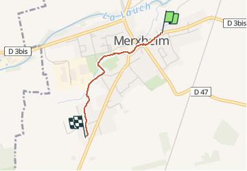

Length
1.6 km

Max alt
223 m

Uphill gradient
10 m
Km-Effort
1.7 km

Min alt
215 m

Downhill gradient
4 m
Boucle
No
Creation date :
2021-01-17 10:55:20.028
Updated on :
2021-01-17 11:18:44.962
23m
Difficulty : Very easy

FREE GPS app for hiking
 SityTrail
IGN / Geographical institutes
SityTrail Plus
The world is yours!
About
Trail Walking of 1.6 km to be discovered at Grand Est, Haut-Rhin, Merxheim. This trail is proposed by flader.
Description
1
Positioning
Country:
France
Region :
Grand Est
Department/Province :
Haut-Rhin
Municipality :
Merxheim
Location:
Unknown
Start:(Dec)
Start:(UTM)
372671 ; 5307918 (32T) N.
Comments