Mn2 Ger menhir

LouisROGER
User GUIDE
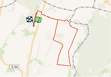

Length
9.8 km

Max alt
402 m

Uphill gradient
82 m
Km-Effort
10.9 km

Min alt
376 m

Downhill gradient
83 m
Boucle
Yes
Creation date :
2021-01-18 07:31:59.233
Updated on :
2021-01-18 09:45:51.608
2h13
Difficulty : Very easy

FREE GPS app for hiking
 SityTrail
IGN / Geographical institutes
SityTrail Plus
The world is yours!
About
Trail Nordic walking of 9.8 km to be discovered at New Aquitaine, Pyrénées-Atlantiques, Ger. This trail is proposed by LouisROGER.
Positioning
Country:
France
Region :
New Aquitaine
Department/Province :
Pyrénées-Atlantiques
Municipality :
Ger
Location:
Unknown
Start:(Dec)
Start:(UTM)
739601 ; 4795447 (30T) N.
Comments