


lac chzmadelle

cagna
User
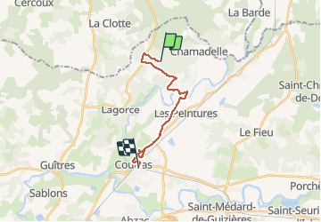

Length
16.1 km

Max alt
82 m

Uphill gradient
94 m
Km-Effort
17.5 km

Min alt
7 m

Downhill gradient
125 m
Boucle
No
Creation date :
2021-01-19 14:10:58.749
Updated on :
2021-01-20 13:46:08.74
23h31
Difficulty : Very easy

FREE GPS app for hiking
 SityTrail
IGN / Geographical institutes
SityTrail Plus
The world is yours!
About
Trail Walking of 16.1 km to be discovered at New Aquitaine, Gironde, Chamadelle. This trail is proposed by cagna.
Description
parcours tran s uillr
Positioning
Country:
France
Region :
New Aquitaine
Department/Province :
Gironde
Municipality :
Chamadelle
Location:
Unknown
Start:(Dec)
Start:(UTM)
727658 ; 4997837 (30T) N.
Comments