Trail Mountain bike Vaugneray - Belle boucle!  800m sur 24kms. - Photo

Belle boucle! 800m sur 24kms.

 dup69
dup69

User

© OpenStreetMap contributors
Length
Length
25 km
Max alt
Max alt
743 m
Uphill gradient
Uphill gradient
828 m
Km-Effort
Km-Effort  
36 km
Min alt
Min alt
300 m
Downhill gradient
Downhill gradient
828 m
Boucle
Boucle
Yes
Creation date :
2021-01-24 07:56:35.534
Updated on :
2021-01-24 12:38:49.891

(1 Reviews)

Mountain bike
Mountain bike
3h00
Difficulty : Medium

Scan this QR Code to open this trail in the SityTrail application

FREE GPS app for hiking

Logo SityTrail SityTrail

IGN / Geographical institutes

Download SityTrail from the App Store Download SityTrail from Google Play

Logo SityTrail SityTrail World

The world is yours!

Download SityTrail from the App Store Download SityTrail from Google Play Download SityTrail on Huawei AppGallery

About

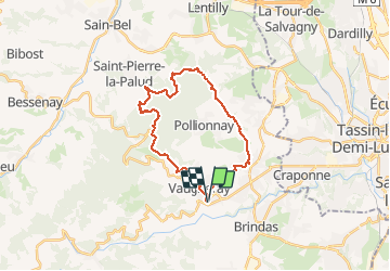
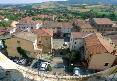
Trail Mountain bike of 25 km to be discovered at Auvergne-Rhône-Alpes, Rhône, Vaugneray. This trail is proposed by dup69.

Description

départ et arrivée de Vaugneray.
parcours varié avec de bons monotraces techniques dans les monts du Lyonnais...
3 heures en roulant tranquillement sinon 2h30.

Elevation profile

Positioning

Country:
France
Region :
Auvergne-Rhône-Alpes
Department/Province :
Rhône
Municipality :
Vaugneray
Location:
Vaugneray
Start:(UTM)
629441 ; 5065574 (31T) N.

Comments

Please log in to post a review or rate the element


Trails nearby

Trail Walking Craponne - départ cimetière de Craponne - Photo
Walking
mimi69670

Walking

Easy
(1)
Craponne, Auvergne-Rhône-Alpes, Métropole de Lyon, France
10.3 km | 13.1 km-effort
2h 36min
Yes
Trail Walking Pollionnay - Pollionnay, Croix du Ban,  la Luère 7,5 Km - Photo
Walking
tracegps

Walking

Medium
(2)
Pollionnay, Auvergne-Rhône-Alpes, Rhône, France
7.3 km | 12 km-effort
2h 0min
Yes
Trail Walking Pollionnay - Pollionnay - Col de la Croix du Ban - Saint Bel - Photo
Walking
jacques delaporte

Walking

Very difficult
(1)
Pollionnay, Auvergne-Rhône-Alpes, Rhône, France
28 km | 40 km-effort
9h 9min
Yes
Trail Walking Messimy - De Messimy au belvédère du Piragoy en boucle - Photo
Walking
galain

Walking

Easy
(1)
Messimy, Auvergne-Rhône-Alpes, Rhône, France
9.6 km | 13.6 km-effort
2h 31min
Yes
Trail Walking Vaugneray - Sur les hauteurs de Vaugneray - Photo
Walking
tracegps

Walking

Medium
(4)
Vaugneray, Auvergne-Rhône-Alpes, Rhône, France
12.5 km | 19.2 km-effort
4h 0min
Yes
Trail Walking Vaugneray - Vaugneray - Lac D'Yseron- Parc Animalier de Courzieu - Photo
Walking
jacques delaporte

Walking

Very difficult
(1)
Vaugneray, Auvergne-Rhône-Alpes, Rhône, France
38 km | 58 km-effort
13h 13min
Yes
Trail Mountain bike Messimy - monté technique - Photo
Mountain bike
journoud

Mountain bike

Difficult
(1)
Messimy, Auvergne-Rhône-Alpes, Rhône, France
26 km | 41 km-effort
3h 15min
Yes
Trail Mountain bike Vaugneray - VTT VAUGNERAY - Photo
Mountain bike
skwick

Mountain bike

Difficult
(1)
Vaugneray, Auvergne-Rhône-Alpes, Rhône, France
17.4 km | 26 km-effort
Unknown
Yes
Trail Mountain bike Grézieu-la-Varenne - scott25 - Photo
Mountain bike
bernardberard

Mountain bike

Very easy
(1)
Grézieu-la-Varenne, Auvergne-Rhône-Alpes, Rhône, France
26 km | 37 km-effort
Unknown
Yes


Close
My subscriptions