Trail Walking Vaugneray - Vaugneray - Lac D'Yseron- Parc Animalier de Courzieu - Photo

Vaugneray - Lac D'Yseron- Parc Animalier de Courzieu

© OpenStreetMap contributors
Length
Length
38 km
Max alt
Max alt
858 m
Uphill gradient
Uphill gradient
1486 m
Km-Effort
Km-Effort  
58 km
Min alt
Min alt
363 m
Downhill gradient
Downhill gradient
1484 m
Boucle
Boucle
Yes
Creation date :
2021-03-18 15:02:45.556
Updated on :
2021-03-18 15:05:40.734

(1 Reviews)

Walking
Walking
13h13
Difficulty : Very difficult

Scan this QR Code to open this trail in the SityTrail application

FREE GPS app for hiking

Logo SityTrail SityTrail

IGN / Geographical institutes

Download SityTrail from the App Store Download SityTrail from Google Play

Logo SityTrail SityTrail World

The world is yours!

Download SityTrail from the App Store Download SityTrail from Google Play Download SityTrail on Huawei AppGallery

About

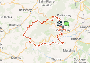
Trail Walking of 38 km to be discovered at Auvergne-Rhône-Alpes, Rhône, Vaugneray. This trail is proposed by jacques delaporte.

Elevation profile

Photos

Positioning

Country:
France
Region :
Auvergne-Rhône-Alpes
Department/Province :
Rhône
Municipality :
Vaugneray
Location:
Vaugneray
Start:(UTM)
628942 ; 5066327 (31T) N.

Comments

Please log in to post a review or rate the element


Fin De rando assez difficile mais on ne se lasse toujours pas des monts Lyonnais 😂


Trails nearby

Trail Walking Pollionnay - Pollionnay, Croix du Ban,  la Luère 7,5 Km - Photo
Walking
tracegps

Walking

Medium
(2)
Pollionnay, Auvergne-Rhône-Alpes, Rhône, France
7.3 km | 12 km-effort
2h 0min
Yes
Trail Walking Pollionnay - Pollionnay - Col de la Croix du Ban - Saint Bel - Photo
Walking
jacques delaporte

Walking

Very difficult
(1)
Pollionnay, Auvergne-Rhône-Alpes, Rhône, France
28 km | 40 km-effort
9h 9min
Yes
Trail Walking Messimy - De Messimy au belvédère du Piragoy en boucle - Photo
Walking
galain

Walking

Easy
(1)
Messimy, Auvergne-Rhône-Alpes, Rhône, France
9.6 km | 13.6 km-effort
2h 31min
Yes
Trail Walking Vaugneray - Sur les hauteurs de Vaugneray - Photo
Walking
tracegps

Walking

Medium
(4)
Vaugneray, Auvergne-Rhône-Alpes, Rhône, France
12.5 km | 19.2 km-effort
4h 0min
Yes
Trail Walking Marcy-l'Étoile - 69 Marcy l'Etoile et les Monts du Lyonnais - Photo
Walking
Maryma

Walking

Medium
(1)
Marcy-l'Étoile, Auvergne-Rhône-Alpes, Métropole de Lyon, France
22 km | 30 km-effort
5h 0min
Yes
Trail Walking Saint-Pierre-la-Palud - Croix du ban - Col de la Luère - St Bonnet le froid - Photo
Walking
daniellebou

Walking

Difficult
(1)
Saint-Pierre-la-Palud, Auvergne-Rhône-Alpes, Rhône, France
9.6 km | 14.3 km-effort
3h 15min
Yes
Trail Mountain bike Vaugneray - Belle boucle!  800m sur 24kms. - Photo
Mountain bike
dup69

Mountain bike

Medium
(1)
Vaugneray, Auvergne-Rhône-Alpes, Rhône, France
25 km | 36 km-effort
3h 0min
Yes
Trail Horseback riding Sainte-Consorce - Balade en forêt  - Photo
Horseback riding
c.decqcaillet

Horseback riding

Easy
(1)
Sainte-Consorce, Auvergne-Rhône-Alpes, Rhône, France
6.5 km | 8.8 km-effort
1h 17min
Yes
Trail Mountain bike Messimy - monté technique - Photo
Mountain bike
journoud

Mountain bike

Difficult
(1)
Messimy, Auvergne-Rhône-Alpes, Rhône, France
26 km | 41 km-effort
3h 15min
Yes


Close
My subscriptions