Trail Walking Valdoule - Le Duffre - Photo
 GAPIAN43
GAPIAN43

User

© OpenStreetMap contributors
Length
Length
10.9 km
Max alt
Max alt
1745 m
Uphill gradient
Uphill gradient
840 m
Km-Effort
Km-Effort  
22 km
Min alt
Min alt
935 m
Downhill gradient
Downhill gradient
838 m
Boucle
Boucle
Yes
Creation date :
2014-12-10 00:00:00.0
Updated on :
2014-12-10 00:00:00.0

(0 Reviews)

Walking
Walking
5h00
Difficulty : Medium

Scan this QR Code to open this trail in the SityTrail application

FREE GPS app for hiking

Logo SityTrail SityTrail

IGN / Geographical institutes

Download SityTrail from the App Store Download SityTrail from Google Play

Logo SityTrail SityTrail World

The world is yours!

Download SityTrail from the App Store Download SityTrail from Google Play Download SityTrail on Huawei AppGallery

About

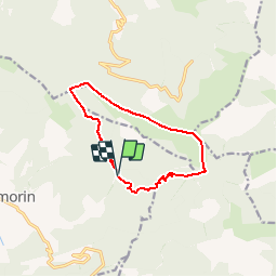
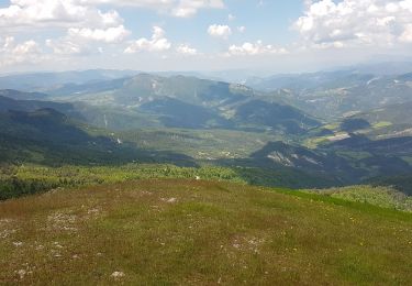
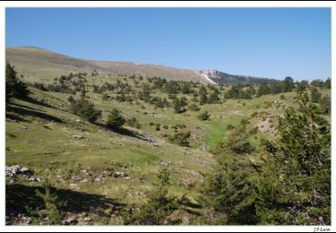
Trail Walking of 10.9 km to be discovered at Provence-Alpes-Côte d'Azur, Hautes-Alpes, Valdoule. This trail is proposed by GAPIAN43.

Description

Le Duffre Coté Sud Montmorin Depuis la MF de l Adoux doule

Elevation profile

Positioning

Country:
France
Region :
Provence-Alpes-Côte d'Azur
Department/Province :
Hautes-Alpes
Municipality :
Valdoule
Location:
Unknown
Start:(UTM)
705265 ; 4925770 (31T) N.

Trails nearby

Trail Mountain bike La Piarre - VTT27 - Sous le Duffre - Photo
Mountain bike
GUIDE+

Mountain bike

Difficult
La Piarre, Provence-Alpes-Côte d'Azur, Hautes-Alpes, France
25 km | 41 km-effort
3h 0min
Yes
Trail Mountain bike La Piarre - VTT24 - De La Piarre à Valdrôme - Photo
Mountain bike
GUIDE+

Mountain bike

Difficult
La Piarre, Provence-Alpes-Côte d'Azur, Hautes-Alpes, France
22 km | 34 km-effort
3h 0min
Yes
Trail Walking Valdrôme - R34   Le Duffre - Photo
Walking
GUIDE+

Walking

Easy
Valdrôme, Auvergne-Rhône-Alpes, Drôme, France
6.9 km | 11.5 km-effort
2h 25min
Yes
Trail Walking L'Épine - Le Bonnet rouge - Photo
Walking
Marco05

Walking

Medium
L'Épine, Provence-Alpes-Côte d'Azur, Hautes-Alpes, France
10.8 km | 20 km-effort
4h 32min
Yes
Trail Walking Ribeyret - Sommet de la Maraysse - Photo
Walking
PapouBertrand

Walking

Difficult
Ribeyret, Provence-Alpes-Côte d'Azur, Hautes-Alpes, France
9.2 km | 18.1 km-effort
5h 50min
Yes
Trail Walking Valdrôme - Valdrome - Montagne de l Aup - Photo
Walking
jean-marie.parachini

Walking

Medium
Valdrôme, Auvergne-Rhône-Alpes, Drôme, France
9.2 km | 16.3 km-effort
12h 6min
Yes
Trail Walking Valdrôme - STATION DE VALDRÔME - MONTAGNE DE L' AUP - Photo
Walking
jean-marie.parachini

Walking

Difficult
Valdrôme, Auvergne-Rhône-Alpes, Drôme, France
9.4 km | 16.5 km-effort
7h 40min
Yes
Trail Walking Valdrôme - Les crêtes du Duffre - Le Pré Pourri - Photo
Walking
tracegps

Walking

Medium
Valdrôme, Auvergne-Rhône-Alpes, Drôme, France
6.4 km | 11.2 km-effort
3h 0min
Yes
Trail Walking Valdrôme - L'Aup Froid - Station de Valdrôme - Photo
Walking
tracegps

Walking

Easy
Valdrôme, Auvergne-Rhône-Alpes, Drôme, France
4.4 km | 6.7 km-effort
2h 0min
Yes


Close
My subscriptions