


correncon

mthomas30
User
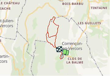

Length
13.3 km

Max alt
1312 m

Uphill gradient
266 m
Km-Effort
16.9 km

Min alt
1153 m

Downhill gradient
283 m
Boucle
No
Creation date :
2021-02-04 09:45:01.945
Updated on :
2021-02-04 13:34:42.661
3h48
Difficulty : Medium

FREE GPS app for hiking
 SityTrail
IGN / Geographical institutes
SityTrail Plus
The world is yours!
About
Trail Cross-country skiing of 13.3 km to be discovered at Auvergne-Rhône-Alpes, Isère, Corrençon-en-Vercors. This trail is proposed by mthomas30.
Positioning
Country:
France
Region :
Auvergne-Rhône-Alpes
Department/Province :
Isère
Municipality :
Corrençon-en-Vercors
Location:
Unknown
Start:(Dec)
Start:(UTM)
698143 ; 4988407 (31T) N.
Comments