Trail Mountain bike Rilhac-Rancon - cassepierre- uzuarat- limoges -le palais- cassepierre - Photo

cassepierre- uzuarat- limoges -le palais- cassepierre

 jpbosso
jpbosso

User

© OpenStreetMap contributors
Length
Length
41 km
Max alt
Max alt
365 m
Uphill gradient
Uphill gradient
655 m
Km-Effort
Km-Effort  
49 km
Min alt
Min alt
212 m
Downhill gradient
Downhill gradient
650 m
Boucle
Boucle
No
Creation date :
2021-02-11 08:00:11.745
Updated on :
2021-02-11 08:10:46.09

(0 Reviews)

Mountain bike
Mountain bike
3h25
Difficulty : Very difficult

Scan this QR Code to open this trail in the SityTrail application

FREE GPS app for hiking

Logo SityTrail SityTrail

IGN / Geographical institutes

Download SityTrail from the App Store Download SityTrail from Google Play

Logo SityTrail SityTrail World

The world is yours!

Download SityTrail from the App Store Download SityTrail from Google Play Download SityTrail on Huawei AppGallery

About

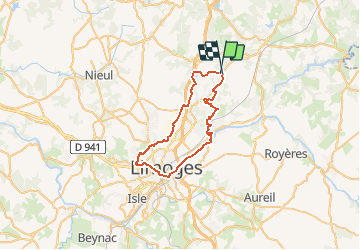
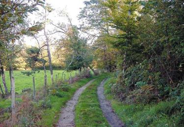
Trail Mountain bike of 41 km to be discovered at New Aquitaine, Haute-Vienne, Rilhac-Rancon. This trail is proposed by jpbosso.

Description

DEPART / Cassepierre resto Chanterelle vers Batissou, n 20 Beaune/mines? Petit Grossereix;  uzurat, vers rucher couzeix, limoges puis bord de Vienne, le Palais,  Rilhac- Rançon et retour Cassepierre resto Chanterelle.
défaut : traversée de   limoges par ville pour rejoindre bords de Vienne.

Elevation profile

Positioning

Country:
France
Region :
New Aquitaine
Department/Province :
Haute-Vienne
Municipality :
Rilhac-Rancon
Location:
Unknown
Start:(UTM)
371264 ; 5087145 (31T) N.

Trails nearby

Trail On foot Rilhac-Rancon - De Rilhac à Payaud et Bramaud - Photo
On foot
000843.e2af63ba812d4dc4a845c93df243350a.2104

On foot

Easy
Rilhac-Rancon, New Aquitaine, Haute-Vienne, France
4.9 km | 6.3 km-effort
1h 25min
Yes
Trail Walking Bonnac-la-Côte - Bonnac la Côte  sentier des vallées fin coupée  - Photo
Walking
coeurdom

Walking

Difficult
Bonnac-la-Côte, New Aquitaine, Haute-Vienne, France
9.9 km | 12.5 km-effort
2h 5min
Yes
Trail Mountain bike Rilhac-Rancon - De Cassepierre à Nieul - Rilhac Rancon - Photo
Mountain bike
tracegps

Mountain bike

Medium
Rilhac-Rancon, New Aquitaine, Haute-Vienne, France
60 km | 72 km-effort
4h 0min
Yes
Trail Walking Saint-Priest-Taurion - Basse et Haute Gorce / Martinerie - Saint-Priest-Taurion - Photo
Walking
tracegps

Walking

Easy
Saint-Priest-Taurion, New Aquitaine, Haute-Vienne, France
3.9 km | 4.9 km-effort
1h 0min
Yes
Trail sport Limoges - La Mazelle_08-05-23_traces - Photo
sport
Mamidomi

sport

Very easy
Limoges, New Aquitaine, Haute-Vienne, France
9.6 km | 11.3 km-effort
Unknown
Yes
Trail Mountain bike Rilhac-Rancon - de - Photo
Mountain bike
pjoly

Mountain bike

Medium
Rilhac-Rancon, New Aquitaine, Haute-Vienne, France
21 km | 25 km-effort
1h 27min
No
Trail Walking Ambazac - OR-7330964--Ambazac:Sentier des Bonhommes 26,261 km  - Photo
Walking
Blogus

Walking

Difficult
Ambazac, New Aquitaine, Haute-Vienne, France
26 km | 36 km-effort
6h 30min
Yes
Trail Other activity Rilhac-Rancon - vallée de la mazelle - Photo
Other activity
rgentet

Other activity

Very easy
Rilhac-Rancon, New Aquitaine, Haute-Vienne, France
2.2 km | 2.8 km-effort
53min
Yes
Trail Other activity Rilhac-Rancon - vallée de la mazelle - Photo
Other activity
rgentet

Other activity

Very easy
Rilhac-Rancon, New Aquitaine, Haute-Vienne, France
2.2 km | 2.8 km-effort
53min
Yes


Close
My subscriptions