Trail Walking Brouchaud - Bouchaud boucle des Mérigots 11 km - Photo

Bouchaud boucle des Mérigots 11 km

 YV24
YV24

User

© OpenStreetMap contributors
Length
Length
10.9 km
Max alt
Max alt
205 m
Uphill gradient
Uphill gradient
214 m
Km-Effort
Km-Effort  
13.8 km
Min alt
Min alt
133 m
Downhill gradient
Downhill gradient
214 m
Boucle
Boucle
Yes
Creation date :
2021-02-13 08:05:15.709
Updated on :
2021-02-14 14:22:54.931

(1 Reviews)

Walking
Walking
2h39
Difficulty : Easy

Scan this QR Code to open this trail in the SityTrail application

FREE GPS app for hiking

Logo SityTrail SityTrail

IGN / Geographical institutes

Download SityTrail from the App Store Download SityTrail from Google Play

Logo SityTrail SityTrail World

The world is yours!

Download SityTrail from the App Store Download SityTrail from Google Play Download SityTrail on Huawei AppGallery

About

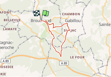
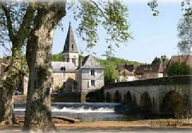
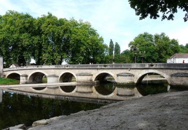
Trail Walking of 10.9 km to be discovered at New Aquitaine, Dordogne, Brouchaud. This trail is proposed by YV24.

Description

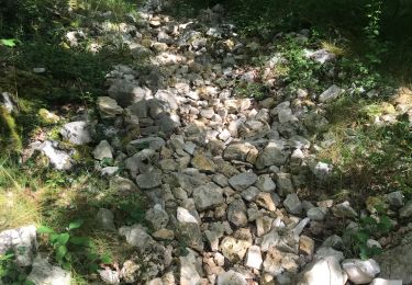
Départ depuis le parking derrière l'ancienne école de Brouchaud. Sentiers et chemins de causse et sous bois, en grande partie ombragés. Praticable en tout temps. Quelques ornières possibles après de très fortes pluies. Tracé à suivre de préférence au GPS, empruntant seulement quelques tronçons de boucles balisées.
Bonne rando.

Elevation profile

Positioning

Country:
France
Region :
New Aquitaine
Department/Province :
Dordogne
Municipality :
Brouchaud
Location:
Unknown
Start:(UTM)
342878 ; 5007788 (31T) N.

Comments

Please log in to post a review or rate the element


superbe ?!!!


Trails nearby

Trail Walking Sainte-Eulalie-d'Ans - Ste Eulalie d'Ans bcle Ste Eulalie - Photo
Walking
YV24

Walking

Easy
(1)
Sainte-Eulalie-d'Ans, New Aquitaine, Dordogne, France
9.7 km | 11.8 km-effort
2h 32min
Yes
Trail Walking Cubjac-Auvézère-Val d'Ans - Le chemin du Causse - Cubjac - Photo
Walking
tracegps

Walking

Medium
Cubjac-Auvézère-Val d'Ans, New Aquitaine, Dordogne, France
7.9 km | 10 km-effort
2h 0min
Yes
Trail Walking Gabillou - boucle des murs en pierres sèches  - Photo
Walking
dmortier

Walking

Medium
Gabillou, New Aquitaine, Dordogne, France
8.8 km | 10.8 km-effort
2h 34min
Yes
Trail Walking Cubjac-Auvézère-Val d'Ans - track - Photo
Walking
houbart

Walking

Very difficult
Cubjac-Auvézère-Val d'Ans, New Aquitaine, Dordogne, France
15.4 km | 19.7 km-effort
4h 28min
Yes
Trail Walking Montagnac-d'Auberoche - Boucle de la fontaine Marceau ( Montagnac d’ Auberoche)  - Photo
Walking
Marc 24

Walking

Easy
Montagnac-d'Auberoche, New Aquitaine, Dordogne, France
6.9 km | 8.6 km-effort
2h 9min
Yes
Trail Walking Cubjac-Auvézère-Val d'Ans - Boucle des Quatre Paroisses - Photo
Walking
CC.RIDER

Walking

Difficult
Cubjac-Auvézère-Val d'Ans, New Aquitaine, Dordogne, France
12.3 km | 15.9 km-effort
3h 36min
Yes
Trail Walking Cubjac-Auvézère-Val d'Ans - Les 4 paroisses - Cubjac - Photo
Walking
tracegps

Walking

Medium
(1)
Cubjac-Auvézère-Val d'Ans, New Aquitaine, Dordogne, France
12.5 km | 16.5 km-effort
3h 0min
Yes
Trail On foot Chourgnac - chourgnac d'ans - Photo
On foot
Patricew

On foot

Easy
Chourgnac, New Aquitaine, Dordogne, France
11.1 km | 13.5 km-effort
3h 3min
Yes
Trail Walking Cubjac-Auvézère-Val d'Ans - CUBJAC 4paroisses Milpas - Photo
Walking
pascalmilpas

Walking

Difficult
Cubjac-Auvézère-Val d'Ans, New Aquitaine, Dordogne, France
12.6 km | 16.3 km-effort
3h 42min
Yes


Close
My subscriptions