


PHR TM Day 7

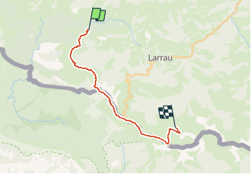
ARVIEU
User

Length
18 km

Max alt
2009 m

Uphill gradient
1190 m
Km-Effort
34 km

Min alt
1306 m

Downhill gradient
1209 m
Boucle
No
Creation date :
2021-02-19 06:23:12.718
Updated on :
2021-02-19 06:24:08.326
7h42
Difficulty : Very difficult

FREE GPS app for hiking
 SityTrail
IGN / Geographical institutes
SityTrail Plus
The world is yours!
About
Trail Walking of 18 km to be discovered at New Aquitaine, Pyrénées-Atlantiques, Larrau. This trail is proposed by ARVIEU.
Positioning
Country:
France
Region :
New Aquitaine
Department/Province :
Pyrénées-Atlantiques
Municipality :
Larrau
Location:
Unknown
Start:(Dec)
Start:(UTM)
660734 ; 4766943 (30T) N.
Comments