


HRP TM Day 11

ARVIEU
User

Length
17.9 km

Max alt
2021 m

Uphill gradient
662 m
Km-Effort
28 km

Min alt
1377 m

Downhill gradient
1125 m
Boucle
No
Creation date :
2021-02-19 06:33:50.771
Updated on :
2021-02-19 06:34:37.559
6h25
Difficulty : Very difficult

FREE GPS app for hiking
 SityTrail
IGN / Geographical institutes
SityTrail Plus
The world is yours!
About
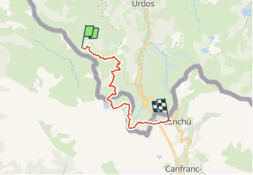
Trail Walking of 17.9 km to be discovered at New Aquitaine, Pyrénées-Atlantiques, Borce. This trail is proposed by ARVIEU.
Positioning
Country:
France
Region :
New Aquitaine
Department/Province :
Pyrénées-Atlantiques
Municipality :
Borce
Location:
Unknown
Start:(Dec)
Start:(UTM)
694839 ; 4745876 (30T) N.
Comments