


LAC NOIR HAUTES HUTTES

jcschubnel
User
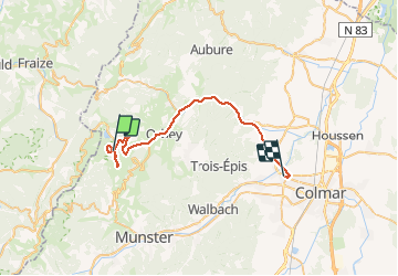

Length
33 km

Max alt
1046 m

Uphill gradient
339 m
Km-Effort
40 km

Min alt
207 m

Downhill gradient
1084 m
Boucle
No
Creation date :
2021-02-12 12:58:33.626
Updated on :
2021-02-20 16:37:45.516
3h15
Difficulty : Very easy

FREE GPS app for hiking
 SityTrail
IGN / Geographical institutes
SityTrail Plus
The world is yours!
About
Trail Walking of 33 km to be discovered at Grand Est, Haut-Rhin, Orbey. This trail is proposed by jcschubnel.
Positioning
Country:
France
Region :
Grand Est
Department/Province :
Haut-Rhin
Municipality :
Orbey
Location:
Unknown
Start:(Dec)
Start:(UTM)
358592 ; 5330569 (32U) N.
Comments