


Pic de Louesque

mitch1952
User
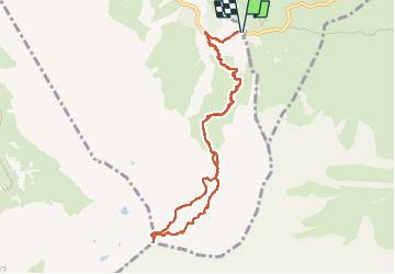

Length
9.9 km

Max alt
2533 m

Uphill gradient
1182 m
Km-Effort
26 km

Min alt
1335 m

Downhill gradient
1175 m
Boucle
Yes
Creation date :
2021-02-20 17:06:22.434
Updated on :
2022-06-08 09:37:58.895
5h49
Difficulty : Very difficult

FREE GPS app for hiking
 SityTrail
IGN / Geographical institutes
SityTrail Plus
The world is yours!
About
Trail Walking of 9.9 km to be discovered at New Aquitaine, Pyrénées-Atlantiques, Béost. This trail is proposed by mitch1952.
Positioning
Country:
France
Region :
New Aquitaine
Department/Province :
Pyrénées-Atlantiques
Municipality :
Béost
Location:
Unknown
Start:(Dec)
Start:(UTM)
721570 ; 4759417 (30T) N.
Comments