


Ribeauvillé

duchaine.nicolas
User

Length
48 km

Max alt
500 m

Uphill gradient
721 m
Km-Effort
58 km

Min alt
178 m

Downhill gradient
722 m
Boucle
Yes
Creation date :
2021-02-20 13:19:12.306
Updated on :
2021-03-21 14:56:02.296
1h15
Difficulty : Very easy
1h15
Difficulty : Very easy

FREE GPS app for hiking
 SityTrail
IGN / Geographical institutes
SityTrail Plus
The world is yours!
About
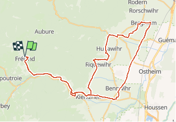
Trail Mountain bike of 48 km to be discovered at Grand Est, Haut-Rhin, Fréland. This trail is proposed by duchaine.nicolas.
Positioning
Country:
France
Region :
Grand Est
Department/Province :
Haut-Rhin
Municipality :
Fréland
Location:
Unknown
Start:(Dec)
Start:(UTM)
365792 ; 5337170 (32U) N.
Comments